
 Translate
Public Safety
Virtual Map Counter
See also: Boundaries for police precinct and district information and Environment for earthquake information.
 |
Print Size: 34 x 44 inches |
|
|
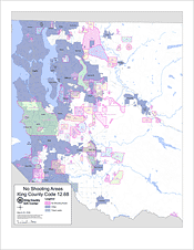
No shooting areas are delineated portions of King County within which the discharge of firearms is prohibited or regulated by King County Code, Title 12, Chapter 12.68. Each no shooting area on the map is labeled with the corresponding code section number and area descriptor. A no shooting area defined by Chapter 12.68 may lie within or extend into an incorporated city, which may have its own laws regulating the discharge of firearms within its boundaries. For more information on King County Code 12.68, see the King County Code on the Metropolitan King County Council website. |
||
 |
Print Size: 36 x 36 inches |
|
|
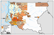
Depicts point locations of reported damage to private business and residential properties during an approximately two-week period after the February 28, 2001, Nisqually Earthquake. Created by the E-911 Program Office in conjunction with the King County Emergency Operations Center. |
||