
 Translate
East King County Groundwater Management Area
This Groundwater Management Area encompasses nearly 225 square miles mostly within the Snoqualmie River Valley. The boundaries extend from the Snohomish -King County border to areas south of North Bend, bounded on the east by the foothills of the Cascade Mountains and on the west by the surface water divide between Bear Creek and Snoqualmie River.
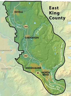
Most of the residential, commercial and industrial land uses are within the cities of Carnation, Duvall, North Bend, and Snoqualmie. The remainder of the management area outside the cities' limits has low density residential, forest and agricultural land uses.
Almost 90% of the water used for private, municipal, and industrial and agricultural purposes in the East King County Groundwater Management Area is provided by groundwater sources.
EKC Groundwater Protection Committee —Inactive as of 2004
Groundwater Data
East King County Groundwater Management Plan
East King County Groundwater Maps and Figures
Water Suppliers in East King County
This Groundwater Management Area has 38 Group A and 247 Group B Public Water Systems. The majority of the residents in this GWMA are serviced by the following Water Utility Service areas:
| Ames Lake | KC Water District 119 | Riverbend |
| Carnation | KC Water District 123 | Sallal |
| Carnation Res. Farm | Lake Margaret | Snoqualmie |
| Duvall | North Bend | Spring Glen |
| Fall City | Redmond | Wilderness Rim |
| Woodinville |
This page is produced by the King County Groundwater Protection Program. To learn more about this group and its responsibilities, please read about the Groundwater Protection Program.