
 Translate
Natural resources reference maps
King County GIS Center Map Hub: environment and natural resources maps
Collection of published maps that go back years.
Cartographic resource maps of King County
This page provides base and thematic maps that King County Dept of Natural Resources and Parks uses in its work. We save digital copies to share with county residents, businesses, government agencies, schools and non-profit organizations to make the full use of our existing maps. These maps are provided in Adobe Acrobat format.
Many of the maps available on this page are complex and require generous download times. We've provided the file sizes and expected download times in the map descriptions to help decide what to download. Here is one of the newest maps on our cartographic maps page:
Maps depict known locations of weed infestations for noxious weed species in King County.
Snoqualmie Watershed riparian photos
View aerial photographs covering individual stream reaches along the Snoqualmie River and its tributaries.
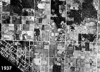
Aerial photos from the 1930's, 1970's, and 1990's illustrating growth of several areas in King County including Bellevue near Meydenbauer Bay, around Cottage Lake near Woodinville, Maplewood near Renton, and Lake Meridian in Kent.
Groundwater interactive map
Zoom in to view the full set of GIS layers including well locations, groundwater sampling sites, wellhead protection areas, water services areas, property boundaries and aerial imagery among other things.
King County geographic information system
View and query maps and data online using iMAP map portal. order a DVD of King County data, or find online descriptions and documentation for King County GIS data in the Spatial Data Catalog. The group also offers a King County, Washington GIS training program.
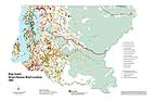
King County watersheds map
This page is a geographic portal to King County information by drainage area. Find out what natural resource information we have and what's going on where you live.
Other map & aerial photo resources
External pages where you can view, download, and order maps and aerial photos of King County.
- University of Washington libraries
Map Collection and Cartographic Information Services; - Microsoft Bing Search maps
- Google maps
- MapMart
Order digital maps and data, paper USGS maps, aerial photos, software, etc.; USGS partner; - Metsker Maps
Massive map selection focusing on the Northwest; - Washington coastal atlas by Washington State Dept. of Ecology (external link). View shoreline aerial photos of every stretch of shoreline in the state and overlay a variety of features such as biological and habitat, physical, and regulated features and shoreline modifications.
- Shoreline aerial photos by Washington State Dept of Ecology (external link). Oblique aerial photos of every stretch of saltwater shoreline in the state.
- CRC Press - environmental science, GIS, mapping
Major studies and publications related to geographic technologies and techniques.
Related information
- King County GIS Center
- King County watersheds map
- iMAP - map portal
- Property research and maps
- Publications
- Environmental education