
 Translate
Maury Island Natural Area Fill Removal Project
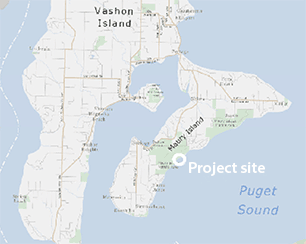
Vashon-Maury Island
Project overview
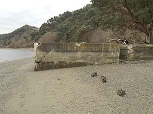
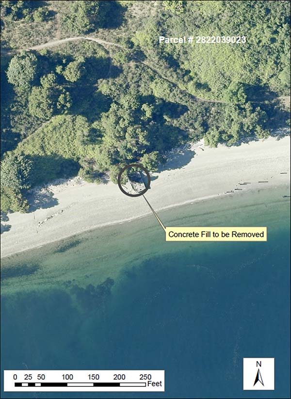
King County will remove a 57’x25’ concrete pier, located on the southeast shoreline of Maury Island on what was previously the Glacier gravel mine site. The pier has two sections, one where the decking material has been removed and has accumulated driftwood over time, and a landward section with a concrete lid. The dock has a concrete L-shaped footing extending approximately 18” below grade at the seaward corner. The total volume of concrete to be removed is approximately 111 CY. Conservatively, the total volume of material to be removed from this pier site and disposed of could total 239 CY (111 CY of concrete, 128 CY of possible fill inside the landward pier).
Project location
The Maury Island Fill Removal Project is located within the Maury Island Natural Area on the southeast shoreline of Maury Island in Central Puget Sound. It is the site of the former Glacier gravel mine as well as other mines and is east of the town of Dockton. The 250 acre property is owned by King County and is managed as "Ecological Land." The project site is in the NW quarter of Section 28, Township 22N, Range 03E; Thomas Bros. page7I3 at H4.
Project benefit
The goal is to restore beach-forming processes to a 60 by 25 foot area on the shoreline. Beach-forming processes will be restored and beach spawning fish habitat will be improved at the site by removing approximately 111 cubic yards of concrete from a former pier and approximately 128 cubic yards of material that may have been placed inside a portion of the pier. If the material found within the pier is native beach material it will be left in place. Beach wood found in the open portion of the pier will be left on the beach.
Project timeline
| Benchmark | Date |
| Project Start | March 2014 |
| Project Design - Start | July 2014 |
| Construction | September 2015 |
| Project Completion | December 2015 |
What to expect during construction
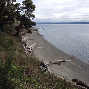
Construction access to the site will be from land. Removal of the pier will be facilitated with the use of a small excavator at the site and a small tracked 5 CY hauler. Demolition materials will be loaded into the tracked hauler, which will transport the material along the upper edge of the beach to a constructed access ramp 1,500 feet to the south (adjacent to the large gravel mine dock). A construction staging area at the top of the ramp will be used to stockpile and load demolition materials into dump trucks for transport and disposal at a concrete recycling facility off the island. The constructed access ramp will remain after construction.
Please send comments regarding this project to Deborah Pessoa, the Project Manager:
Deborah Pessoa
206-477-5643
Deborah.Pessoa@kingcounty.gov
King County Water and Land Resources Division
201 South Jackson Street, Suite 600
Seattle, WA 98104-3855
Please note that the formal SEPA Comment Period will be open through June 17, 2015.
Project documents
The Maury Island Natural Area Fill Removal Project documents are available in Adobe Acrobat format. For help using Acrobat files, please visit our Acrobat help page.
- SEPA Environmental Checklist (203 KB)
- SEPA Determination of Non-Significance (127 KB)
- Permit plan set (1.5 MB)
For more information about the Maury Island Natural Area Fill Removal Project, please contact Deborah Pessoa, Engineer III, Rural & Regional Services Section.