
 Translate
Holmes Point summary report
December 1997
King County
Department of Development and Environmental Services
Table of Contents
Descriptive Analysis of the Holmes Point Planning Area
Zoning and Landuse Issues - Three Planning Options
Community Response to Planning Options
DPER Recommendation and Analysis
Appendix:
A. Finn Hill Community Plan
- Page 1
- Page 2
B. Holmes Point Forum #1 Summary
- Page 1
- Page 2
C. Holmes Point Forum #2 Summary
- Page 1
- Page 2
- Page 3
- Page 4
D. Surface Water Management Programs
- Page 1
- Page 2
- Page 3
- Page 4
- Page 5
- Page 6
Figure 1
Holmes Point Planning Area
Adobe Acrobat File (422K)
As part of the 1997 Budget, the Metropolitan King County Council requested that the Department of Development and Environmental Services (now known as the Department of Permitting and Environmental Services (DPER)), evaluate the existing zoning in the Holmes Point Planning Area. (Figure1) This report consists of a brief history of development, land use and zoning in the Holmes Point Planning Area, a description of the area's natural environment and other issues, a summary of three options for responding to these issues, a summary of the public process and community response to the options, and DPER recommendations. After further public input, these recommendations will be incorporated into the 1998 Executive Proposed Amendments to the King County Comprehensive Plan.
Summary of Recommendations
- Develop a Holmes Point Special District Overlay which provides for a maximum site disturbance limit.
- Develop a Holmes Point Special District Overlay which limits on-site development on sensitive sites, but allows for a transfer of development rights.
Settlement Patterns
The earliest recorded activities of the first settlers were of lumbering, farming and trade undertaken for half a century starting in the 1860's.
Finn Hill was named for the Finns, such as the Tollber family and John Reuth who came to that area in 1869. The hill was first logged off in the early 1900's. Otto Reine bought 10 acres on Finn Hill (for $500), cut cedar and skidded logs to Juanita on a chute. The Lake Park Land Company constructed landings north and south of O.O. Denny Park and subsidized steamers to attract investors and land purchasers. (See Figure 2)
Northshore Community Plan - 1977, 1981, 1993
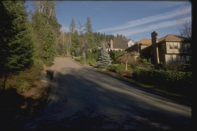
The Holmes Point Planning Area, located on the northeast shore of Lake Washington between St. Edwards St. Park and Juanita Bay, is part of the Northshore Community Plan area, which has been one of the fastest growing parts of King County (its population grew at an average rate of almost four percent per year during the 1980's).
The first iteration of the Northshore Community Plan and Area Zoning, adopted in 1977 zoned most of the Holmes Point area RS-15,000 (one home per 15,000 square feet, or about three homes per acre), with some RS-7,200 along the waterfront.
In 1993 the Area Zoning for Holmes Point as well as other parts of the Northshore Community Planning Area was amended to include special development conditions (P-suffix) that imposed requirements in addition to those in existing County development regulations relating to stormwater retention/detention, and the retention of significant trees. Residents of Holmes Point requested that the County consider downzoning the area, but the RS-15,000 and RS-7200 zoning was retained.
King County Comprehensive Plan and Area Zoning - 1994
In response to the mandate of the Washington State Growth Management Act of 1991 King County undertook a comprehensive planning effort which culminated in revised zoning classifications throughout the County.
The 1994 KCCP contains written policy guidance for urban residential development, environmental protection and adequacy of public services, and a Land Use Map that designates the Holmes Point Planning Area as Residential, R-4 dwelling units per acre. The new Zoning Code's residential zones are density based rather than lot size based, and contain zones equivalent to all those in the old code except RS-15,000.
During the conversion process, DDES applied either R-1 (residential, one dwelling unit per acre, 50 percent clustering required), or R-4 (residential, four dwellings per acre) to areas previously zoned RS-15,000. The RS-15,000 zoning in the Holmes Point Planning area was predominately converted to R-4, the lowest density classification routinely given within within the Urban Growth Boundary Area. The RS-7,200 zoning was converted to R-6 ( residential, six dwellings per acre).
In addition newly mapped sensitive areas were delineated, using the King County Geographic Information System (GIS).
Descriptive Analysis of the Holmes Point Planning Area
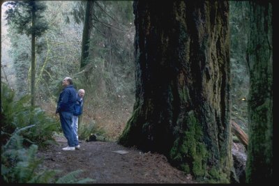
The Holmes Point Planning Area which includes the Champaigne Point district is the south portion of the Finn Hill premonitory with underlying soils of highly erosive unconsolidated glacial and non-glacial soils. (Figure 4) From the eastern boundary which is primarily described by Juanita Drive, the planning area falls west and south to Lake Washington and is characterized by steep forested slopes and ravines, from which springs and surface water collect, including the salmonid bearing class two stream, Denny Creek.
The study area encompasses the largest contiguous natural area on Lake Washington, most of which is in public ownership. There is a mosaic of second growth forest types which provide habitat for eagle, heron, owls, pileated woodpecker, coyote and a host of other wildlife species as well as a regionally significant recreational amenity. (Figure 3)
Figure 3
GIS Orthophotographic Map
Adobe Acrobat File (184K)
Residential development is characterized by three types of development characteristics. Fed by locally accessible arterials off Juanita Drive, the "crown" of hill residences lay out on relatively flat land and have a variety of street types that serve them. The two other characteristic types are served by the main arterial of Holmes Point Drive and are the "shoreline" residences, and residences that reach up the "ravines" via fingerling lanes serving houses on the flanks and flats, with some eventually reaching the ridges.
Recent Residential
Historic Character
Figure 4
Geological and Hydrological
Sensitive Areas Features
Adobe Acrobat File (215K)
Crown (Undeveloped)
Ravine (Undeveloped)
Shoreline (Public)
Street Character at Crown Residential
Heavy Disturbance Ravine Residential
Shoreline R-6 at edge of Public Land
Street Character at Crown Residential
Minimum Disturbance Ravine Residential
Street Character at Holmes Point Dr. major loop arterial
Sustainable Development Forum - 1996
In response to constituent concerns over the impacts of the 1994 Comprehensive Plan upzone to R-4, King County Councilwoman Maggi Fimia conducted a public forum about protections available from existing King County regulations. (Note: the planning area is now in the council district of Councilwoman Jane Hague) The April 30 Forum presented county staff who discussed existing regulations regarding zoning, site planning, and incentive programs. A commitment was made to continue the dialogue about Holmes Point and the need to initiate a 1997 planning study which would look at land use issues. There was a discussion of future funding for the restoration of Denny Creek.
Holmes Point Forums - 1997
In July of 1997 a planning study was initiated to review community land use issues. Public meetings were conducted on September 17, October 23, and December 18, 1997.
- September 17 Forum began with a gallery of GIS maps which described conditions within the planning area. The project goals were introduced, historic land use and permitting were reviewed, and three discussion groups gathered comments on issues of concern.
Participants: 83 citizens, and 6 King County staff.
Results: An Issues Summary and recorded comments from all discuss- ion groups. These were researched and developed into community response documents distributed at the next forum. - October 23 Forum began with a review of the handouts which included project boundaries, questions and answers from the September 17 Forum, a delineation of issues summary, and a King County human resource file. Three planning options intended to respond to these issues were reviewed and discussed, and a comment sheet was distributed to gather the community response
Participants: 73 citizens, and 5 King County staff.
Results: 162 returned community comment sheets. - December 18 Forum presented there commendations of DDES to the citizens. A discussion of the recommendation followed, and the process of legislative and public review were described.
Here is a summary of issues from the many comments gathered at the September 17 Forum:
Resource Based:
- Improve Surface Water Management Practices to reduce erosion and siltation.
- Enforce and/or Improve Significant Tree and Site Disturbance Standards.
- The Holmes Point Area is unique because of the surrounding publicly owned contiguous forest lands and water basins, and the great percentage of sensitive areas within the residential zone.
- King County should recognize the ecological value of this area. This could include increased protections and an initiative to study the existing health of the resources and implement a comprehensive area and water basin restoration plans.
Development Based:
- Land Owners have based their plans on zoned development potentials.
- The "Character" of the Holmes Point Community has been based on a variety of housing clustered naturally because of the extensive sensitive areas. This includes narrow roadways and significant forest canopy.
- Threats to this character include: required road widenings; reduced forest canopy; increased erosion and siltation; the potential for denser residential development.
- Road Standards should be reviewed to allow neighborhood input based on "existing character" while meeting safety requirements.
- Urban Density R4 zoning overlayed on a predominately "sensitive area" is inappropriate.
- There is a loss of trust in King County enforcing regulations. This is thought to be the result of a loss of field personnel, and a prodevelopment attitude towards inspections and variances.
- There is a loss of trust in King County enforcing regulations. This is thought to be the result of a loss of field personnel, and a prodevelopment
Figure 5
Comprehensive Plan Land Use
Adobe Acrobat File (215K)
Zoning and Land Use Issues - Three Planning Options
The discussion of options focused mostly on possible changes to the R-4 zoning on the slopes above Holmes Point Drive between St. Edwards State Park and O.O. Denny Park. The southern part of the Holmes Point Planning Area between O.O. Denny Park and Champaigne Point has environmentally sensitive areas and would be within the scope of these options, although it has more R-6 than R-4 zoning. (Figures 5, 6, and 7)
The three options as described to the community are as follows with some explanatory text:
A. Keep Existing R-4 Zoning with greater community under standing and access to King County protections and services.
This is essentially the no-action alternative, although it could be combined with increased code enforcement, field inspections and technical assistance to applicants subject to the Significant Trees Special District Overlay (K.C.C.21A.39.220).
B. Keep R-4 Zoning but add an overlay district which provides more stringent disturbance standards.
This alternative would replace the current Significant Trees Special District Overlay with a lot by lot limit on site disturbance and impervious surfaces. The existing special requirements for stormwater retention remain in effect. In addition the overlay would provide more guidance to King County for granting variances, to encourage maximum protection of ground cover.
C. Downzone to R-1 in King County mapped sensitive areas, plus more stringent site disturbance standards.
This alternative would involve reclassifying to R-1 almost all of the R-4, and much of the R-6 zoning in the portions of the Holmes Point Planning Area accessed by Holmes Point Drive NE. This alternative would also require a map amendment to the 1994 King County Comprehensive Plan Land Use Map, to redesignate the areas recommended to be downsized from Urban Residential, 4-12 dwelling unit per acre to Urban Residential, 1 dwelling unit per acre.
Figure 6
Planning Area Existing Zoning Map
Adobe Acrobat File (217K)
Community Response to the Planning Options
The Holmes Point Planning Areas response to the planning options suggested to them was vigorous and clear in their preferences. There was a community initiated response which linked Options B and C, which in effect created another category of response.
A tally of the survey results:
| A | 8 | Keep Existing R-4 Zoning with greater community understanding and access to King County protections and services. |
| B | 36 | Keep R-4 Zoning but add an overlay district which provides more stringent disturbance standards. |
| B-C | 81 |
Keep R-4 Zoning but add and overlay district which provides more stringent disturbance standards; Downzone to R-1 in mapped sensitive areas. "B - This is the right option for the majority of the planning area; C - this is the right option for a small area considered 'urban sensitive' meaning steep slopes and stream setbacks" (quote from standard text reply) |
| C | 37 | Downzone to R-1 in King County mapped sensitive areas, plus more stringent site disturbance standards. |
| 162 | Total Citizen Comments Received |
Figure 7
Parcels >= 0.5 Acres; Sensitive Areas Map
Adobe Acrobat File (218K)
DDES Recommendation and Analysis
The Department of Development and Environmental Services recommends that the existing R-4 and R-6 zoning in the Holmes Point Planning Area be retained, and that site disturbance limits be applied to the King County mapped sensitive areas in the form of two new overlays which would be suitable for use in areas with underlying zoning of R-1, R-4, and R-6.
In the Holmes Point Planning Area these overlays would replace the current Significant Trees Overlay. Use of the recommended overlays in urban residential areas such as Holmes Point would provide an increased level of protection for environmentally sensitive areas, including Denny Creek, steep slopes and the vicinities very active landslide hazard areas (the northern portion of Holmes Point Drive NE was closed for several months in 1997 due to severe mudslides following the heavy snow and rain of December 1996 and January 1997).
Limiting site disturbance would help minimize the impacts of infill development in the area, and encourage retention of tree and other vegetative cover vital to preserving the areas high value as wildlife habitat. At the same time the use of overlays while retaining the R-4 and R-6 zoning would preserve a significant amount of residential growth capacity within the Urban Growth Area (downzoning the area to R-1 was estimated to reduce theoretical potential capacity in the area by 700 or more dwelling units). Therefore, their application to Holmes Point would be consistent with and help implement the following KCCP policies:
• U-501 King County should encourage new residential development to occur in Urban Growth Areas where facilities and services can be provided at the lowest public cost and in a timely fashion. The Urban Growth Area should have a variety of housing types and prices, including mobile home parks, multifamily development, townhouses, and small-lot, single-family development.
• U-503 In the Urban Growth Area, King County should use regulations, incentives, open space acquisition, or , where these measures are not adequate,King County may use low density zoning to protect floodplains, critical aquifer recharge areas, Regionally or Locally Significant Resource Areas, high value wetlands and unstable slopes from degradation, and to encourage linking these environmental features into a network of open space, fish and wildlife habitat and urban separators.
Comparison of Proposed Overlay Site Disturbance/Impervious Surface Limits with Existing Code
The recommended overlays would have the following features:
1. Minimum Site Disturbance Overlay
This overlay would "waive/supplant K.C.C. 21A.12's minimum and maximum density and impervious surface limits" and establish a lot by lot "site disturbance limit" similar to that in the 1989 Bear Creek Community Plan (P-suffix condition P-5), with separate requirements for new development vs. remodeling. Clearing, grading and impervious surfaces would be limited on a sliding scale based on lot size (see matrix comparing overlay limits with current impervious surface limits in K.C.C. 21A.12).
This overlay would also replace the "significant tree retention" requirement now in place in the Holmes Point Planning Area (not for the rest of Northshore Community Plan Area however); and provide criteria for flexibility (10 percent increase in impervious surfaces at the Director's discretion) in granting variances from both the overlay and standard requirements to encourage minimal site disturbance.
2. Minimum Site Disturbance/Density Transfer Overlay
Same features as the Minimum Site Disturbance Overlay, and would also limit on-site development to one to three lots and provide for transferring density credits on larger, more sensitive sites.
| R-1* | R-4* | R-6* | R-8* | |
|
Current Limits KCC 21.A.12.030 Impervious Surface |
16,335 sq. ft. lot* entire lot can be cleared/graded 4,900 sq. ft. |
8,168 sq. ft. lot entire lot can be cleared/graded 4,492 sq. ft. |
5,445 sq. ft. lot entire lot can be cleared/graded 3,811 sq.ft. |
4,084 sq. ft. lot entire lot can be cleared/graded 3,471 sq. ft. |
|
Proposed Overlay** Total Site Disturbance |
4,033 sq. ft. | 3,067 sq. ft. | 2600 sq. ft. | N/A |
* These zones have no minimum lot sizes: therefore a "typical" lot size was computed by subtracting 25 percent of a 43,560-sq.ft. site for roads and drainage facilities, and then dividing by the indicated base density number; the resulting lot size is given in the cell for each zone. R-8 is shown because its limits would apply in the other zones if a subdivision were clustered to produce lots typical of R-8.
** The recommended overlay limits site disturbance based on lot size, regardless of zone; the "typical" lot size developed for each zone is used as an example, but the example would apply to any lot of a given size regardless of underlying zone.
*Note: To view PDFs, free software from Adobe is required. Word documents require Microsoft software. For assistance, see helpful hints.
To request this information in alternate formats for people with disabilities, call 206-296-6600 or TTY Relay: 711.