
 Translate
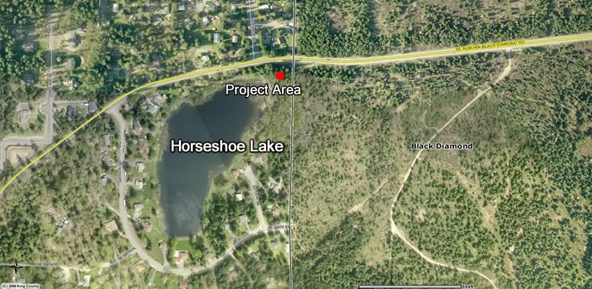
Horseshoe Lake Flood Reduction Project
Horseshoe Lake is a closed depression located in unincorporated King County just west of the City of Black Diamond. There are fifteen single family residences along the waterfront. Horseshoe Lake does not have a surface water outlet however it is hydraulically connected to groundwater and is subject to rapid changes in elevation. The rising water level of Horseshoe Lake threatens both homes and infrastructure. Emergency pumping of Horseshoe Lake is required to maintain roadway access, protect property and protect the environment by preventing flooding of septic systems. King County has performed emergency pumping multiple times since the early 1990’s.
Project Overview
Re-establishing equipment access and clearing of an area to place a pump each time that there is a threat of flooding is costly, time consuming and creates the potential for an unintended expansion of impacts adjacent to the edge of Horseshoe Lake. King County DNRP is designing a project to permanently establish an access driveway from SE Auburn-Black Diamond Road to Horseshoe Lake and to stabilize an existing 12” diameter, 350 foot long section of pipeline. A temporary pump will be installed during pumping operations. This project will connect to a pipeline that runs approximately 1 mile to the south and discharges at an infiltration facility. See the attached documents for details on the proposed project.
Project Goals
- Reduce threat of flooding to Horseshoe Lake residences and infrastructure.
- Establish Permanent Access Road and location for future pumping operations.
Project Timeline
| Milestone | Date |
|---|---|
| Completion of SEPA Process | Late 2019 |
| Completion of Environmental Review and Permitting | Mid 2020 |
| Construction | 2023 |
Project Documents
SEPA Documents
Environmental Information related to proposal (Documents e and l will not be publicly distributed):
- a. Horseshoe Lake Pumping Project Water Quality Analysis Technical Memorandum, May 24, 2018, by Herrera (1MB)
- b. King County Surface Water Design Manual-Technical Information Report –Targeted Drainage Review, by King County WLRD, August 4, 2015 (2.4MB)
- c. Water Quality: 2014 Pumping Event from Horseshoe Lake to a Gravel Pit in The Villages Proposed Development, by King County Science and Technical Support Section, July 2014 (8.2MB)
- d. Critical Areas Study, Wetland Delineation of Horseshoe Lake Pumping Area, by King County Roads Maintenance Division, July 31, 2015 (10.9MB)
- e. Addendum to the Cultural Resources Inventory for the Reserve at Woodlands Phase I, King County, Washington, January 2015, by Historical Research Associates, Inc., addressing the portion of The Reserve at Woodlands site and those portions of The Villages Master Planned Development site impacted by the HLFCP
- f. Sensitive Area Study, Buffer Restoration Plan and Buffer Vegetation Management Plan for The Villages Infiltration Test Pipeline, January 15, 2015, by Wetland Resources, Inc., addressing City of Black Diamond wetland buffer impacts and proposed mitigation associated with the directional bore of the pipeline under a wetland located within the City of Black Diamond (2.5MB)
- g. Critical Area Study and Buffer Restoration Plan, The Villages Infiltration Test Pipeline, January 14, 2015, addressing King County wetland buffer impacts and proposed mitigation associated with the directional bore of the pipeline under a wetland located within unincorporated King County (2.5MB)
- h. Reserve at Woodlands Infiltration Testing and Monitoring Strategy, King County, Washington, April 21, 2015, by Golder Associates, describing the groundwater and surface water monitoring that was proposed to monitor the Infiltration Facility and surrounding area (917KB)
- i. 2016 Horseshoe Lake Emergency Pumping-Groundwater Monitoring, October 2016, by Eric Ferguson, King County WLRD (1.1MB)
- j. Development Agreement between King County, Washington and BD Village Partners, LP (approved under King County Ordinance 17745), February 13, 2014 (8.3MB) (“Development Agreement”), describing the ownership, development, operation, and maintenance of an infiltration facility, more specifically described in Development Agreement Sections 6.4 - 6.5 “(Infiltration Facility”), a pipeline from Horseshoe Lake to that Infiltration Facility, and pumping of Horseshoe Lake. The Development Agreement contains specific anticipated actions that are binding upon the parties with regard to Horseshoe Lake pumping, construction of a conveyance pipeline, and development of the Infiltration Facility.
- k. Muckleshoot Indian Tribe. 2017. The Crisp Creek watershed: Current conditions and risks. Prepared by the Muckleshoot Indian Tribe Fisheries Division. January 30, 2017 (4.3MB). Auburn, Washington.
- l. The Reserve at Woodlands Infiltration Test Pipeline Project Cultural Resources Assessment, prepared by ESA Associates, August 10, 2015 to ensure compliance with Washington state laws, including RCW 27.53 (Archaeological Sites and Resources), RCW 27.44 (Indian Graves and Records), and RCW 68.60 (Abandoned and Historic Cemeteries and Graves).
- m. 2017 Horseshoe Lake Emergency Pumping – Surface Water Monitoring 2016-2017, dated May 2018 (5.3MB), Prepared by Rachael Gravon, King County WLRD, Seattle, Washington.
- n. 2017 Horseshoe Lake Emergency Pumping-Groundwater Monitoring, May 2018 (1.7MB), by Eric Ferguson, King County WLRD, Seattle, Washington.
- o. Sensitive Areas Study, Buffer Averaging Plan, and Wildlife Analysis for Ten Trails MPD Phase 2 Plat A Preliminary Plat – prepared by Wetland Resources, Inc. (8.2MB) (as revised on July 12, 2018).