
 Translate
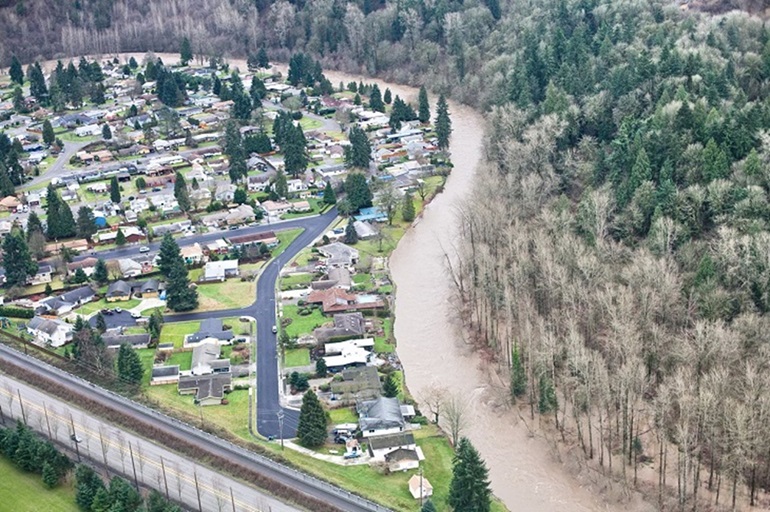
Maplewood Landslide and Flood Risk Reduction Feasibility Study
Project update and noise alert
Several homes within the Maplewood neighborhood are at risk from river flooding and bank erosion and could be surrounded by water and isolated during a 100-year flood event. The extent of flood hazards could be affected by potential landslides from the steep slopes along the opposite river bank.
King County, as the service provider to the King County Flood Control District, will be collecting the necessary data along these slopes to evaluate flood-related hazards and determine how best to address them. Once we know more, we will share this information with the neighborhood and other stakeholders. We expect to hold a neighborhood meeting in late fall or winter 2018, when our initial hazard assessment should be complete.
For additional information and project updates, please contact Kate Akyuz, project manager, by email or 206-477-4607. Or, sign up for email updates about the project.
Project overview
The Maplewood neighborhood is located within the City of Renton between State Route 169 and the Cedar River. Several homes in the neighborhood are at risk from river flooding and bank erosion. These risks could increase if a landslide large enough to interact with the river were to occur on the steep slope on the opposite side of the river from the neighborhood. The slope is mapped as a potential landslide hazard and has a history of landslide activity. The problem area was identified in the Draft Cedar River Capital Investment Strategy.
This project will analyze these flood and landslide hazards and potential associated risk in the Maplewood neighborhood. It will include an analysis of existing levees to see if levee-modifications could mitigate flood risks. If the landslide hazard assessment indicates the potential to increase flood risks, an additional feasibility study will be conducted to evaluate options to mitigate landslide hazards.
At this point, funding is for a risk analysis and the development of alternatives for mitigating the risk. Funding does not include the selection of a preferred alternative or the design and construction of the selected alternative.
Project goals
- The completion of a landslide hazard and flood risk assessment for the Cedar River reach that runs past the Maplewood neighborhood.
- Feasibility study to determine if modifications to the Erickson Levee can mitigate flood risks along the right bank of the Maplewood neighborhood.
- If a landslide hazard assessment indicates a potential to contribute to flooding, an additional feasibility study to evaluate landslide hazard mitigation options.
Project timeline
| Benchmark |
Date |
|---|---|
| Flood and landslide hazard and risk assessment begins |
April 2018 |
| Hazard assessment completed |
August 2018 |
| Risk analysis completed |
December 2018 |
| Development of potential risk mitigation solutions |
January 2019 |
Project documents
Level 1 Landslide Hazard Assessment (King County, 2018) (14 MB)