
 Translate
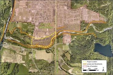
Lower Frew Levee Setback Project
Project overview
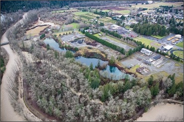
The Lower Frew Levee Setback project is in the City of Carnation on the northern bank of the Tolt River, between SR 203 and the Snoqualmie Valley Trail. King County, as the primary service provider to the King County Flood Control District, plans to remove the existing Lower Frew Levee and construct a new levee farther away from the river. This will help reduce flood risks and improve habitat along the lower Tolt River.
Most levees on the Tolt River were built more than 60 years ago to protect farmland. The levees constrained the river and disconnected it from its historic floodplain. Moving the levee will reconnect the river to 34 acres of floodplain and provide critical habitat for fish while reducing flood and riverbank erosion risks to people, property, roads, and bridges.
The recreational Tolt River Trail will be rebuilt on top of the new setback levee. The trail will provide a link between the Snoqualmie Valley Trail and Tolt MacDonald Park. As part of this project, King County will also improve the culvert under SR 203 north of the Tolt River bridge. This will reduce the risk from flooding on the highway.
King County expects to complete the project between 2026 and 2027.
What is a levee?
A levee is a raised structure built along a riverbank to contain, control, or divert the flow of water and protect the land along the river from temporary flooding. A levee is usually made of earth and runs parallel to the course of a river.
Fish habitat conservation
King County is working to protect and restore fish habitat on the Tolt River. The Tolt River is home to Chinook salmon, bull trout, and steelhead trout. These species are all listed as threatened under the Endangered Species Act. This project will support their recovery by restoring access to a side channel of the river. Fish need side channels to lay eggs, known as spawning, and protect young fish from predators.
Project goals
- Reduce flood and riverbank erosion risks to people, property, roads, and bridges.
- Improve habitat for salmon and other fish.
- Engage with tribes, residents, City of Carnation, and other stakeholders to identify how the project can best reduce flood risks, improve habitat, and provide opportunities for recreation.
- Limit disruption to SR 203, Tolt MacDonald Park, and recreational trails during construction.
Project schedule
| Activity | Date |
|---|---|
| Collect data and information | 2020 to 2022 |
| Design and permitting | 2022 to 2025 |
| Construction | 2026 to 2027 |
Construction impacts
King County is working to limit the impacts of construction. Traffic control and potential road or lane closures to SR 203 may be necessary at times during construction. King County will close the Tolt River Trail between SR 203 and the Snoqualmie Valley Trail for safety during construction.
We will update this webpage with further impacts to SR 203, Tolt MacDonald Park, and trails in the area as the project moves through design and permitting. We will also post signs and flyers near the project site and notify local businesses and residents before and during construction. To receive updates, please sign up for the project email list.