
 Translate
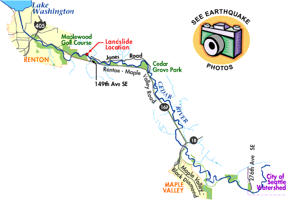
Cedar River Landslide
On February 28, 2001 the ground motion from the Nisqually earthquake triggered a landslide on the north side of the Cedar River near the Maplewood Golf Course. The slide crossed the lower Cedar River completely filling about 600 feet of the channel with mud and debris. For a short time most of the river's flow was held back by this natural blockage. Water impounded behind this mass of debris began flooding a few of the homes above the blockage. A Renton streets supervisor called equipment and crews to the scene from a nearby construction site and used three excavators to open a different channel around the slide.
The crews were able to excavate through the south river bank, upstream of the landslide, and connect the river to a pre-existing side channel. Once this short connection was made, water rushed through the opening and the full flow of the Cedar River was redirected to the side channel. The diverted flow prevented additional flooding and the water impounded behind the landslide quickly began to drop.
The area of the former side channel (now a part of the main channel) is extremely dangerous. Several large trees have been undercut by the river and have fallen in the area. The area of the slide is still very unstable and another slide could occur at any time.
Citizens are advised to stay away from the area and to respect the City of Renton's closure of the area. The new channel and pre-existing channel are eroding and adjusting rapidly to accommodate the full flow of the river. While this is happening the banks of the river will continue to be cut by the river and several more trees will likely fall. Please stay out of the area.