
 Translate
Rock Creek Natural Area
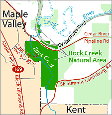
The 143-acre Rock Creek Natural Area is located just east of Maple Valley. The majority of the site lies between the Cedar River Trail to the north and Summit-Landsburg Road to the south, and incorporated Maple Valley to the west and Danville-Georgetown (also called Maple Ridge Highlands) Open Space to the east. The site also includes three acres at the confluence of Rock Creek with the Cedar River.
Most of the site was purchased through the Waterways 2000 effort to help preserve water and habitat quality in the Cedar River Watershed; portions of the site were purchased through the Cedar River Legacy program.
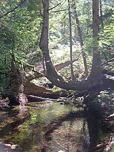
Rock Creek Natural Area contains mature coniferous or mixed coniferous-deciduous forest over most of its acreage. Contiguous with hundreds of acres of forest land to the east, Rock Creek Natural Area supports extensive wildlife use including large mammals such as deer and elk. Rock Creek flows perennially through the site; the upper extent of Rock Creek Natural Area is at approximately river mile 1.3. The site's high-quality mature forest along the creek provides important benefits such as shading and organic material input. Rock Creek is recognized for its exceptional value as Cedar River tributary habitat for chinook, sockeye and coho salmon, and steelhead and cutthroat trout.
Rock Creek Natural Area is appropriate for low-impact public use on the trail system, primarily for walking and nature observation. Trails on the east side of the site extend between the Cedar River Trail and Seattle's Pipeline Road, through the east side of Rock Creek Natural Area, and onto Danville/Georgetown (Maple Ridge Highlands) Open Space just to the east. There are no trail connections across Rock Creek. The west side has a small trail system which is accessible at the SE 252nd Street terminus off of 238th Ave SE in Maple Valley.
The The Rock Creek Site Management Plan written in 1996 under the Waterways 2000 program is available in Adobe Acrobat format. For help using Acrobat files, please visit our Acrobat help page.