We currently offer language translations on our site primarily through Google Translate. This helps visitors find and use information in the languages they speak, but the tool is not perfect. Automated translation may be inaccurate or errors may display on translated pages.
Google Translate is an external website. King County does not control the quality or accuracy of translated content.
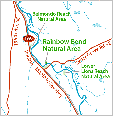
Rainbow Bend Natural Area is located on the right bank of the Cedar River, on SE 180th Street off of Cedar River Grove Road. The site is approximately three miles north of Maple Valley. This property is less than one acre in size, located among residential properties on a peninsula of land extending into the river. The Cedar Grove Mobile Home Park occupies a 20-acre parcel at the northern end of the peninsula.
The Rainbow Bend levee runs along the southern edge of the natural area. The entire peninsula lies completely within the 100-year floodplain; the floodway (the area of deepest and fastest flows) extends across much of the riverward side of the peninsula. Recent flooding in the 1990s inundated most of the land within the floodplain.
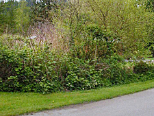
The Rainbow Bend parcel is densely vegetated with shrubs and deciduous trees, with a small wetland area in part of the site. Dense vegetation restricts entry into the site. Neighboring residents might access the property along the levee, though this is not accessible to the general public.
The Rainbow Bend Natural Area Site Management Guidelines are available in Adobe Acrobat format, in sections for faster download. For help using Acrobat files, please visit our Acrobat help page.

 Translate