We currently offer language translations on our site primarily through Google Translate. This helps visitors find and use information in the languages they speak, but the tool is not perfect. Automated translation may be inaccurate or errors may display on translated pages.
Google Translate is an external website. King County does not control the quality or accuracy of translated content.
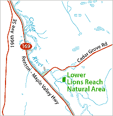
Lower Lions Reach Natural Area is located on the left bank of the Cedar River at approximately River Mile 11.6. This property is approximately three miles north of Maple Valley. The site is within the 'Lower Lions Reach' of the Lower Cedar River as identified by the Cedar River Legacy program, located between River Mile 11.3 and River Mile 11.7.
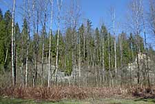
This small site is just over two acres in size. The site lies entirely in the floodplain on a meander bend of the Cedar, and a former side channel of the Cedar River is located on the north part of the property. The southern portion of this site was cleared in the past for a home; the northern portion supports deciduous trees and a dense understory of non-native knotweed.
A restoration project affecting the Natural Area and adjacent Lions Club property will restore the former side channel across the north part of the Natural Area. The project will construct side channel entrance and outlet, grade channel to reflect site hydrology and to mimic natural side channel functions, replant site with native plants, and perform invasive species control. Due to restoration work planned for this site in 2005-2006, this site is not recommended for use by the public at this time.
The Lower Lions Reach Natural Area Site Management Guidelines are available in Adobe Acrobat format, in sections for faster download. For help using Acrobat files, please visit our Acrobat help page.

 Translate