We currently offer language translations on our site primarily through Google Translate. This helps visitors find and use information in the languages they speak, but the tool is not perfect. Automated translation may be inaccurate or errors may display on translated pages.
Google Translate is an external website. King County does not control the quality or accuracy of translated content.
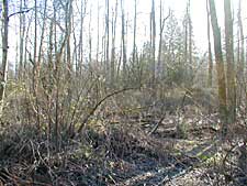
Fall City Natural Area is located 1.5 miles north of Fall City and lies between the Snoqualmie River to the west and the 3000 block of Neal Road to the east and north. The 46.9-acre property lies within the Snoqualmie River's 100-year floodplain and is one of the few substantial blocks of forested riparian habitat in the Snoqualmie Valley. The Fall City Natural Area was purchased to protect the site's remaining high quality salmon habitat, specifically chinook winter rearing and juvenile habitat. The site was purchased between December 2000 and April 2001 with a combination of funding from the Governor's Salmon Recovery Office, a Salmon Recovery Funding Board Grant and King County Shoreline Improvement Funds.
Current public use at Fall City Natural Area involves a relatively low number of visitors engaged in recreational activities such as walking, nature observation and fishing. No formal public trails exist on the site, although pedestrians use the primitive access road as a trail.
The Neal Road Riparian Enhancement Project has been underway since April 2002. The project aims to restore the lowland-forested floodplain by planting native trees species and controlling noxious, invasive and non-native plant species. To date, well over 1,000 trees have been planted.
The Fall City Natural Area Site Management Guidelines are available in Adobe Acrobat format, in sections for faster download. For help using Acrobat files, please visit our Acrobat help page.

 Translate