
 Translate
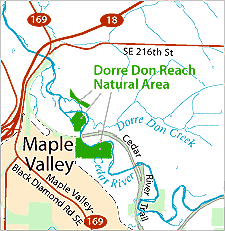
Dorre Don Natural Area
Dorre Don Reach Natural Area is located within the "Dorre Don Reach" of the Cedar River, approximately River Mile 15.5 to 17.1 as defined by the Cedar River Legacy Program. The property is northeast of Maple Valley and the SR 18/169 interchange.,
Portions of the site lie entirely in the floodplain and mapped channel migration hazard area, supporting a side channel, wetlands, and cottonwood-dominated riparian forest. Other parts of the site lie at higher elevations supporting fairly mature second-growth coniferous forests are locations on both sides of the river.
The site is used at fairly low levels for walking and nature observation by local residents. The Cedar River Trail runs through part of the Natural Area; small informal trails lead off the Trail into the site west of a trail bridge across the river. The northern parts of the site lack legal public access.
The Dorre Don Reach Natural Area Site Management Guidelines are available in Adobe Acrobat format, in sections for faster download. For help using Acrobat files, please visit our Acrobat help page.
Download Here:
Dorre Don Reach Natural Area Site Management Guidelines