
 Translate
Channel migration hazards
What is channel migration?
Channel migration is a special type of flood hazard. Channel migration is a natural process that describes how rivers can change their paths over time. River pathways are called channels, and river channels can move, or migrate, across their floodplains. Channel migration can happen over hundreds of years as a river slowly moves sand and gravel from one side of the riverbank to another. Channel migration can also happen as an abrupt movement of the river to a new location, which is called an avulsion. An avulsion can happen during a single flood event.
There are many areas in King County where migrating river channels may endanger houses, barns, roads, bridges and offices. Channel migration is most common in areas where sediment is deposited quicker than other areas of a river. Sediment is deposited quickly when a river, or part of a river, has more sediment than the flowing river water can carry. For example, where a steep river flows out of foothills onto a flatter floodplain, sediment can be deposited resulting in the river channel migrating.
Why map channel migration?
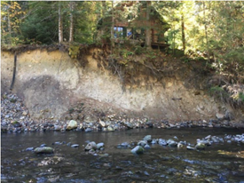
As rivers change course, floodplains and hazardous areas around them also change. Erosion caused by channel migration can threaten houses, roads, and infrastructure by washing away the ground from underneath them. When this happens slowly over time, we can respond to the changes and make sure people, buildings, and animals are all out of the danger zone.
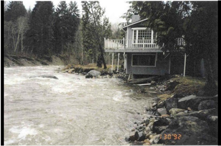
An avulsion can change the course of a river very quickly and endanger homes and businesses farther from or above the existing channel. An avulsion during a flood may be the least recognized, yet most destructive type of flood hazard. King County staff study and map channel migration to better predict where channel migration might happen to protect communities living near and in those areas.
What is a Channel Migration Zone study?
A channel migration zone study is when experts look at important geological factors to determine when and how a river channel may move over time in a particular area, or zone. Experts study historical channel locations, geology, river flood history, what riverbanks are made of, current channel conditions, abandoned channels and potential avulsion sites, channel migration rates, and existing infrastructure. Historical channel migration across the floodplain is measured and calculated. All this information helps experts better define each channel migration zone and assess risks to keep the community informed.
Channel migration zone regulations
In unincorporated King County, there are special construction regulations for areas of severe and moderate channel migration hazard. New development is not allowed within the severe hazard area of the channel migration zone and new development may be restricted within the moderate hazard area of the channel migration zone.
For full information on channel migration zone regulations, please refer to the following King County codes:
King County Department of Local Services, Permitting Division Adopted Public Rules
The public rule was last revised in 2014 to be consistent with the 2012 King County Shoreline Master Plan update, channel migration zone provisions in the Washington Administrative Code (WAC 173-26-221(3)(b)) and Washington State Department of Ecology guidance on channel migration zone mapping. The authority to update the public rule is granted in King County Code 2.98, 21A.02 and 21A.24.
The public rule is amended each time a new channel migration zone map is adopted by the Department of Local Services.
Channel migration hazard maps
You can use iMAP interactive maps to view Channel Migration Hazard Maps. For detailed information on how to use iMAP please read this how-to guide.
How to read channel migration zone maps
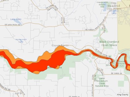
Below is an example of a channel migration zone map from iMap. Severe channel migration hazard areas are shaded in red and moderate channel migration hazard areas are shaded in orange. Other geological and built features are not shown unless you select them in the Layers List.
Channel Migration Zone mapping in King County
Current channel migration zone maps are prepared using mapping methods specified in the King County Channel Migration Zone Public Rule [link], consistent with policies in the King County Flood Hazard Management Plan, Washington State Shoreline Management Act, and the Washington State Department of Ecology Channel Migration Assessment. The process includes gathering and considering comments from the public.
Each Channel Migration Zone (CMZ) map:
- Identifies areas that are at risk from channel migration hazards.
- Regulates land use within the mapped area
- Helps property owners make informed land use decisions
King County has studied and mapped CMZs along the following major rivers:
Greenwater River from River Mile 1.2 to the White River confluence
The Greenwater River CMZ study and map were completed in 2022. The amended channel migration public rule became effective March 14, 2022.
For more information, you can look at the final map and related study:
2022 Greenwater River channel migration zone map (4.9 MB, PDF)
2022 Greenwater River channel migration zone study and map (11.0 MB, PDF)
Paper copies are available for review at the following two locations:
- King County Department of Local Services – Permitting Division, 35030 SE Douglas Street, Suite 210, Snoqualmie, WA
- Enumclaw Library, 1700 1st Street, Enumclaw, WA
Middle White River from Mud Mountain Dam to downstream of the State Route 410 bridge crossing, River Mile 28 to River Mile 20 (2019)
The Middle White River CMZ study and map were completed in 2019. The amended channel migration public rule became effective December 25, 2019.
For more information, you can look at the final map and related study:
2019 Middle White River channel migration zone map (1.23 MB, PDF)
2019 Middle White River channel migration study and map (55.5 MB, PDF)
Paper copies are available for review at the following two locations:
- King County Department of Local Services – Permitting Division, 35030 SE Douglas Street, Suite 210, Snoqualmie, WA
- Enumclaw Library, 1700 1st Street, Enumclaw, WA
Raging River from River Mile 8.5 to the confluence with the Lower Snoqualmie River at River Mile 0 (2019)
The Raging River Channel Migration Zone (CMZ) study and map were completed in 2019. The amended channel migration public rule became effective December 25, 2019.
For more information, you can look at the final map and related study:
2019 Raging River channel migration zone map (2.50 MB, PDF)
2019 Raging River channel migration study and map (44.2 MB, PDF)
Paper copies are available for review at the following two locations:
- King County Department of Local Services – Permitting Division, 35030 SE Douglas Street, Suite 210, Snoqualmie, WA
- Fall City Library, 33415 SE 42nd Place, Fall City, WA
South Fork Skykomish from the confluence of the Foss and Tye Rivers to the King-Snohomish county line, River Mile 19.7 to River Mile 6.6 (2017)
The South Fork Skykomish Channel Migration Zone (CMZ) study and map were completed in 2017. The amended channel migration public rule became effective in September 2017.
For more information, you can look at the final map and related study:
South Fork Skykomish River channel migration zone map (PDF, 1.08 MB)
South Fork Skykomish River channel migration study and map (PDF, 17.2 MB)
Paper copies are available for review at the following two locations:
- King County Department of Local Services – Permitting Division, 35030 SE Douglas Street, Suite 210, Snoqualmie, WA
- Carnation Library, 4804 Tolt Ave, Carnation, WA
Tolt River Update from River Mile 6 to the river's confluence with the Snoqualmie River, River Mile 6 to River Mile 0 (2017)
The Tolt River CMZ study and map were completed in June 2017 and amended in January 2018. The amended channel migration public rule became effective July 13, 2018.
For more information, you can look at the final map, the 2018 reassessment, and the 2017 study and map:
July 13, 2018 Tolt River channel migration zone map (PDF, 1.00 MB)
January 16, 2018 Tolt River CMZ Reassessment Technical Memo (PDF, 3.42 MB)
June 2017 Tolt River channel migration study and map (PDF, 10.25 MB)
Paper copies are available for review at the following two locations:
- King County Department of Local Services – Permitting Division, 35030 SE Douglas Street, Suite 210, Snoqualmie, WA
- Carnation Library, 4804 Tolt Ave, Carnation, WA
Cedar River from Landsburg to the river mouth in Renton, River Mile 22 to River Mile 0 (2015; 2019 Reassessment at River Mile 12.2 to 12.6)
The Cedar River Channel Migration Zone (CMZ) study and map were completed and adopted in June 2015. A smaller portion of this area was reassessed in 2019, resulting in an adjustment to the mapped hazard areas. The map adjustment has been documented per the public rule 21A-24-279A(B)(3). The amended channel migration public rule became effective December 25, 2019.
The 2015 Cedar CMZ Study and Map was also used to inform the Cedar River Corridor Planning process.
For more information, you can look at the adjusted map, 2015 study, and 2019 reassessment:
Adjusted Cedar River channel migration zone map panel 5 (605 KB, PDF)
2015 Cedar River channel migration study and map (32 MB, PDF)
2019 Cedar River CMZ Reassessment Technical Memorandum (836 KB, PDF)
Paper copies are available at the following three locations:
- King County Department of Local Services – Permitting Division, 35030 SE Douglas Street, Suite 210, Snoqualmie, WA
- Fairwood Library, 17009 140th Avenue SE, Renton
- Maple Valley Library, 21844 SE 248th Street, Maple Valley
Studies prior to 2000
1996 Channel Migration in the Three-Forks Area of the Snoqualmie River (5.9 MB, PDF)
1993 Green River Channel Migration Study (4 MB, PDF)
1991 Tolt and Raging Rivers Channel Migration Study (10 MB, PDF)
Don’t see your area represented here? Channel migration is still being studied in King County. The county will host a public meeting for each future channel migration zone study area to present draft mapping and gather public comments.