
 Translate
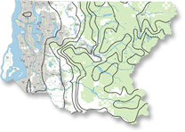
Natural resource maps of King County, Washington
Isopluvial contour map showing average annual precipitation in inches for King County, Washington. Map includes cities, parks and forestlands as of 2010.
Maps depict known locations of weed infestations for noxious weed species in King County. Updated every year.An interactive weed infestation map is also available.
This color lake map displays lakes across King County in different colors depending on their water quality. Lakes may be:
- hypereutrophic - very poor water quality
- eutrophic - poor water quality
- mesotrophic - moderate water quality
- oligotrophic - good water quality
The map also depicts easily readable lake names, rivers and streams and ciities as of March, 2003. Map size is 11" x 17" with landscape orientation. File format is Adobe Acrobat version 5. File size is 1.28 Mb.
This map depicts 100-year and 500-year floodplains in King County, with cities as of December, 1998 and rivers, streams and lakes. The map scale is 1:300,000, map size is 11" x 17", and the orientation is landscape. File size is 1.38 Mb.
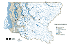
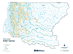
This color map includes Water Resource Inventory Areas (WRIAs), lakes, rivers, streams, shaded relief and cities as of February, 2006. Map size is 11" x 17" with landscape orientation. File format is Adobe Acrobat version 5 and file size is 651 Kb.

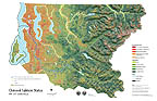
This map depicts land cover derived from a LandSat satellite image taken of King County on August 11, 2001. The map includes shaded relief and water area. The map scale is 1:150,000, map size is 24" x 36", and the orientation is landscape. File size is 4.3 Mb.
This color map includes cities as of April, 2000, lakes, rivers, streams, watersheds and sub-basins. Map size will fit 11" x 17" with landscape orientation, or may be plotted at a 300% enlargement to fit 36" x 48" (E size). File format is Adobe Acrobat version 3. File size is 802 Kb.
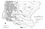
This color map depicts the general distribution and health of chinook stocks in several King County rivers based on a 1997 study by the Washington State Department of Fish and Wildlife. The chinook information overlays land cover imagery that was interpreted from 1995 satellite data, combined with shaded relief imagery that was calculated from a digital elevation model. Other information depicted on the map includes rivers, streams, lakes, and Water Resource Inventory Areas (WRIAs) in King County. The background image has been resampled to minimize file size and downloading time. Map size is 11" x 17" with landscape orientation. File format is Adobe Acrobat version 3. File size is 1.7 Mb.

This color map shows the area in King, Snohomish, and Pierce Counties served by the King County Wastewater Treatment Division as of February, 2000. File format is Adobe Acrobat version 3. File size is 811 Kb.

This color map depicts the corporate boundaries and areas covered by King County's Sewer Utilities as of December, 1999. This map also shows the urban growth boundary, section-township-range grid, roads, and rivers. Map size is 11" x 17" with portrait orientation. File format is Adobe Acrobat version 3. File size is 504 Kb.

This color map depicts the corporate boundaries and areas covered by King County's Water Utilities as of October, 1997. This map also shows the urban growth boundary, section-township-range grid, roads, and rivers. Map size is 11" x 17" with portrait orientation. File format is Adobe Acrobat version 3. File size is 444 Kb.

This color map depicts the service areas of King County's Water Utilities. This map is distinguished from the Water Utility Areas map in that it depicts possible future corporate boundaries for the water utilities and was updated June, 2006. This map also shows the urban growth boundary, section-township-range grid, roads, and rivers. Map size is 11" x 17" with portrait orientation. File format is Adobe Acrobat. and size is 846 Kb.
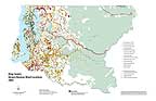
Maps - Known Freshwater Distribution of Salmon and Trout
Maps showing the known distribution of chinook, coho, and sockeye salmon, kokanee, steelhead and cutthroat trout in the greater Lake Washington watershed (WRIA 8), based on the collective personal knowledge of resource professionals and data gathered from published and unpublished databases.
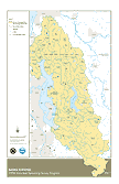
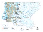
Maps of salmon spawning locations in the Lake Washington, Lake Sammamish, and Cedar River basins. This data was collected by volunteers and King County professional staff during the 1996 spawning season.
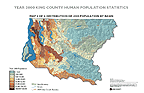
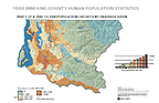
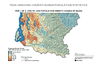
Census Maps
These maps depict population and jurisdiction changes in King County during the decade 1990-2000, by drainage basin.
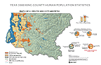
1990-2000 City Annexations (1.91 Mb)