Translate
Recreation Maps
Virtual Map Counter
Distributed throughout more than 25 parks, working forests, and natural areas across urban and rural King County, King County Parks’ backcountry system offers trails with year-round accessibility for hiking, mountain biking, and horseback riding. Each of the map brochures in this series focuses on a different backcountry location and its trail features. Peruse your opportunities for fitness, fun and relaxation, pick a destination, and then print or download a map to take along.
For more information on the backcountry trails system, check out King County Parks’ Backcountry Trails web pages.
The Backcountry Trails map brochures were created by King County Parks and the King County GIS Center.
- Jump to
- Big Finn Hill Park
- Black Diamond Open Space
- Cedar Creek Park
- Cougar Mountain Regional Wildland Park
- Cougar-Squak-Tiger Mountain Corridor
- Danville-Georgetown Open Space
- Dockton Forest and Natural Area
- Duthie Hill Mountain Bike Park
- Frog Holler Forest
- Grand Ridge Park
- Green River Natural Area
- Henry's Ridge Open Space
- Island Center Forest
- Maury Island Marine Park
- Moss Lake Natural Area
- Pinnacle Peak Park
- Rattlesnake Mountain Scenic Area
- Ring Hill Forest
- Shinglemill Creek Preserve
- Soaring Eagle Regional Park
- Spring Lake / Lake Desire Park
- Taylor Mountain Forest
- Tolt River-John MacDonald Park
Big Finn Hill Park
Big Finn Hill Park
preview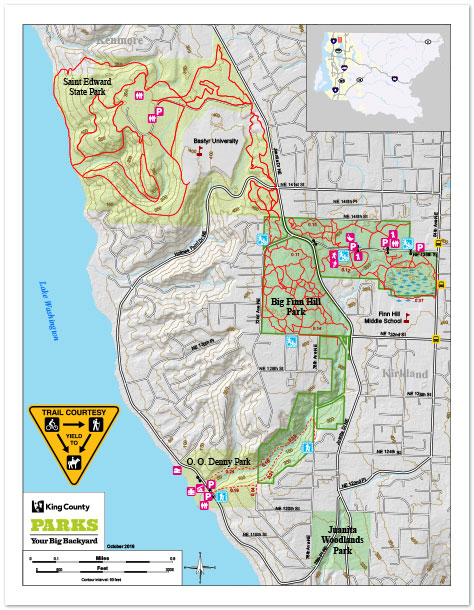
Big Finn Hill Park, the adjoining Saint Edward State Park and the City of Kirkland’s O.O. Denny Park provide more than 16 miles of trails for hiking and biking through a lush forest setting near Lake Washington. Mountain bikers have been coming to the Finn Hill area for years to sample a wide variety of twisty and looping trails that will test all skill levels. Whether walking or riding, Big Finn Hill offers a backcountry trail experience right in the city.
View/download
- Two-page map brochure.
- Designed to print to a letter-size page, two-sided.
- For all devices.
- Folleto de mapas de dos páginas.
- Diseñado para imprimir una pagina de tamaño, por ambos lados.
- Para todos dispositivos.
- One-page geospatial PDF.
- Tap to launch Avenza Maps and load the map.
- For mobile devices only, see below.
- Get the free Avenza Maps app to use geospatial PDFs on your mobile device.
Black Diamond Open Space

Black Diamond Open Space
preview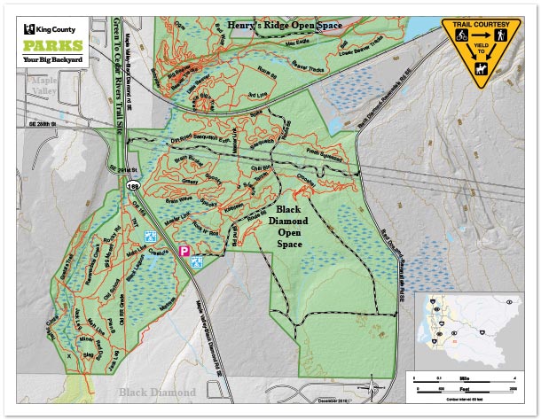
Black Diamond Open Space is a 1,240-acre park located between the cities of Maple Valley and Black Diamond in King County. It is a multi-use King County park managed as three geographic units: north, southwest and southeast units. This map brochure covers the north unit as it is the largest and most publicly used portion of Black Diamond Open Space. The park is forested with several high-quality bogs and wetlands that provide good habitat for wildlife. In 2015, Evergreen Mountain Bike Alliance, the Black Diamond Trails Coalition and King County Parks built a new 10 mile trail network.
Cedar Creek Park
Cedar Creek Park
preview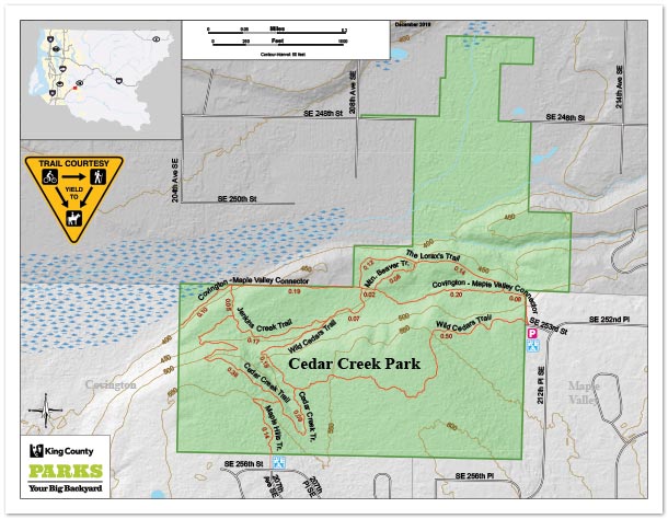
Located between the city limits of Covington and Maple Valley, this unique 120 acre park comprised of almost 100 year old trees is a forested oasis surrounded by development. Owned for decades by Washington’s Department of Natural Resources, and transferred to King County in 2001, this forest has been preserved from logging or development since the 1930’s. Well-loved and used by the community, this site has miles of trails to explore.
Cougar Mountain Regional Wildland Park
Cougar Mountain Regional Wildland Park
preview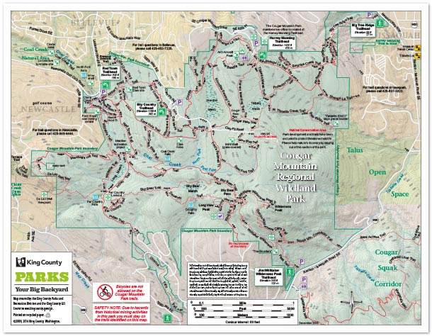
Cougar Mountain Regional Wildland Park is the gem of King County’s 29,000-acre park system. Just minutes from Eastside cities such as Bellevue, Newcastle and Issaquah, Cougar Mountain Park provides an excellent example of our region’s unique historical, cultural and natural heritage. Located in the “Issaquah Alps,” Cougar Mountain Park preserves important wildlife habitat while offering ample opportunities for recreation.
View/download
- Two-page map brochure.
- Designed to print to a letter-size page, two-sided.
- For all devices.
- Folleto de mapas de dos páginas.
- Diseñado para imprimir una pagina de tamaño, por ambos lados.
- Para todos dispositivos.
- One-page geospatial PDF.
- Tap to launch Avenza Maps and load the map.
- For mobile devices only, see below.
- Get the free Avenza Maps app to use geospatial PDFs on your mobile device.
Cougar-Squak-Tiger Mountain Corridor
Cougar-Squak-Tiger Mountain Corridor
preview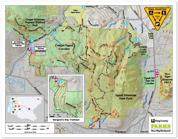
Cougar, Squak and Tiger Mountains, also known as “the Issaquah Alps,” rise above Lake Sammamish and together provide more than 15,000 acres of connected public forest lands. The lands on either side of Squak Mountain create a green “corridor” that connects to Cougar and Tiger mountains. There are more than 100 miles of connected trails and the dense forests and wilderness are home to numerous birds, fish and wildlife.
View/download
- Two-page map brochure.
- Designed to print to a letter-size page, two-sided.
- For all devices.
- Folleto de mapas de dos páginas.
- Diseñado para imprimir una pagina de tamaño, por ambos lados.
- Para todos dispositivos.
- One-page geospatial PDF.
- Tap to launch Avenza Maps and load the map.
- For mobile devices only, see below.
- Get the free Avenza Maps app to use geospatial PDFs on your mobile device.
Danville-Georgetown Open Space
Danville-Georgetown Open Space
preview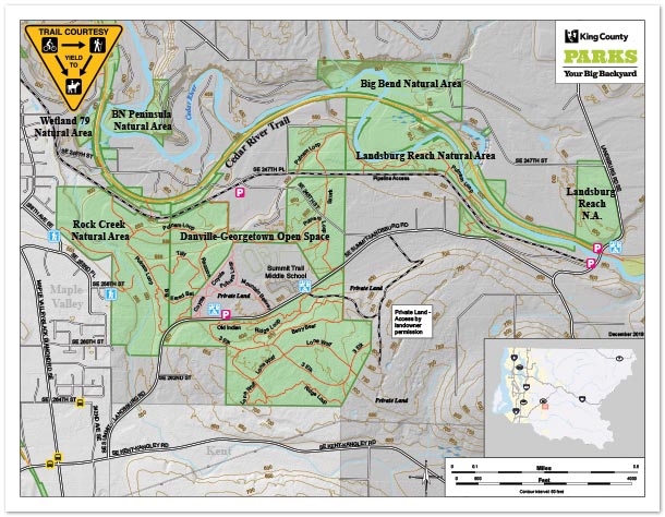
Danville-Georgetown Open Space is a 340-acre park located east of the City of Maple Valley in King County. It is a multi-use King County park named to reflect historical reference to the railroad line that traveled through the site and the former Georgetown mining town. Danville-Georgetown Open Space is predominantly used by hikers and horseback riders who perform the majority of stewardship and trail maintenance at the park.
Dockton Forest and Natural Area

Dockton Forest and Natural Area
preview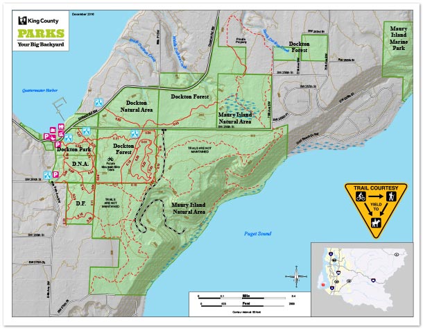
Dockton Forest, Park and Natural Area, along with Maury Island Natural Area make up 469 acres of public open space including over one mile of Puget Sound saltwater shoreline. Located on Maury Island, these open space lands contain an extensive network of recreation trails enjoyed by hikers, runners, equestrians and mountain bikers. Dockton Park provides a public boat launch, moorage and picnic facilities on Quartermaster Harbor. Dockton Forest contains 3 miles of beginner and intermediate mountain bike trails. Maury Island Natural Area was a former gravel mine along Puget Sound that is being restored back to natural forest and shoreline.
View/download
- Two-page map brochure.
- Designed to print to a letter-size page, two-sided.
- For all devices.
- Folleto de mapas de dos páginas.
- Diseñado para imprimir una pagina de tamaño, por ambos lados.
- Para todos dispositivos.
- One-page geospatial PDF.
- Tap to launch Avenza Maps and load the map.
- For mobile devices only, see below.
- Get the free Avenza Maps app to use geospatial PDFs on your mobile device.
Duthie Hill Mountain Bike Park
Duthie Hill Mountain Bike Park
preview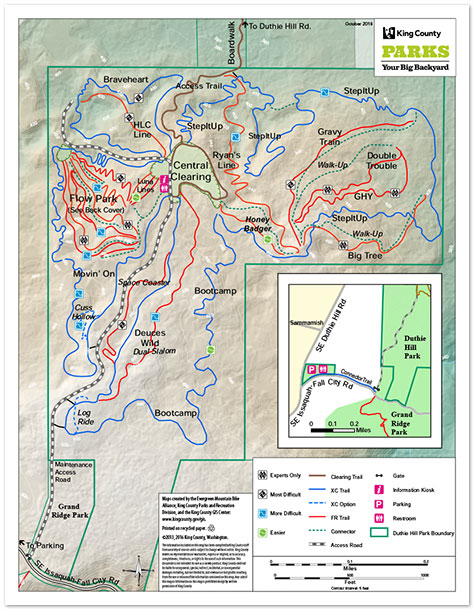
Duthie Hill Park is 136 acres of dense evergreen forest on the Sammamish Plateau. It is connected to more than 2,000 acres of public open space that includes Grand Ridge Park, Mitchell Hill Forest and Preston Ridge Park. The lush rolling forest of Douglas fir and western hemlock provides an excellent setting for the mountain bike park, which was developed in partnership with the Evergreen Mountain Bike Alliance and hundreds of volunteers, as part of King County’s Community Partnership Grant program.
View/download
- Two-page map brochure.
- Designed to print to a letter-size page, two-sided.
- For all devices.
- Folleto de mapas de dos páginas.
- Diseñado para imprimir una pagina de tamaño, por ambos lados.
- Para todos dispositivos.
- One-page geospatial PDF.
- Tap to launch Avenza Maps and load the map.
- For mobile devices only, see below.
- Get the free Avenza Maps app to use geospatial PDFs on your mobile device.
Frog Holler Forest
Frog Holler Forest
preview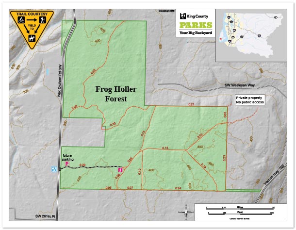
Known for the chorus of tree frogs in the area, Frog Holler is a local Vashon Island neighborhood along Wax Orchard Road just north of Camp Sealth. The 112-acre Frog Holler Forest is one-half mile south of Bates Road on the east side of Wax Orchard Road. The previous owners had enrolled the forest in the American Tree Farm system and allowed local neighbors to use the network of trails on site. The site has a 5-acre pasture that had been grazed by sheep, goats and horses over the years. Frog Holler Forest is the largest public forest on the south end of Vashon Island.
Grand Ridge Park
Grand Ridge Park
preview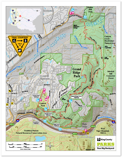
Grand Ridge Park is 1,300 acres of pristine forest rising 1,100 feet in elevation above Issaquah and Lake Sammamish. Established to provide natural resource preservation and passive recreation along the edge of urban and rural living, the park is located between Mitchell Hill Forest to the east and the Issaquah Highlands residential development to the west. The steep slope above the North Fork of Issaquah Creek is covered by stands of large second growth Douglas fir trees.
View/download
- Two-page map brochure.
- Designed to print to a letter-size page, two-sided.
- For all devices.
- Folleto de mapas de dos páginas.
- Diseñado para imprimir una pagina de tamaño, por ambos lados.
- Para todos dispositivos.
- One-page geospatial PDF.
- Tap to launch Avenza Maps and load the map.
- For mobile devices only, see below.
- Get the free Avenza Maps app to use geospatial PDFs on your mobile device.
Green River Natural Area
Green River Natural Area
preview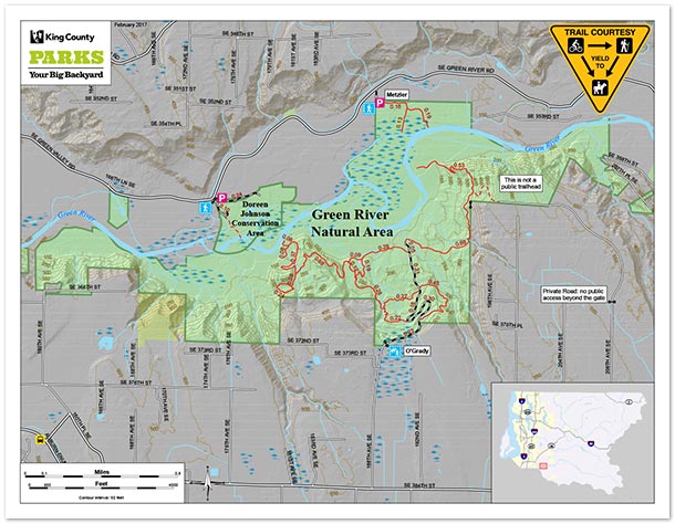
The 1,200-acre Green River Natural Area is a wonderful gateway to the middle stretch of the Green River. Composed of steep valley walls and a broad valley floor, the natural area provides trails for hiking and horseback riding as well as access to the most dynamic reach of the Green River in King County. Mixed evergreen and hardwood forests dominate the upper slopes while the mighty black cottonwoods cover much of the river banks. The Green River provides critical spawning and rearing habitat for coho, chum, Chinook salmon and steelhead.
View/download
- Two-page map brochure.
- Designed to print to a letter-size page, two-sided.
- For all devices.
- Folleto de mapas de dos páginas.
- Diseñado para imprimir una pagina de tamaño, por ambos lados.
- Para todos dispositivos.
- One-page geospatial PDF.
- Tap to launch Avenza Maps and load the map.
- For mobile devices only, see below.
- Get the free Avenza Maps app to use geospatial PDFs on your mobile device.
Henry's Ridge Open Space
Henry's Ridge Open Space
preview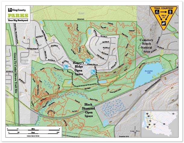
Henry’s Ridge Open Space is a 248-acre park located east of the City of Maple Valley in King County. It is a multi-use King County park that is predominantly used by hikers and mountain bikers who perform the majority of stewardship and trail maintenance at the park. The park is mostly forested with an extensive trail system.
Island Center Forest
Island Center Forest
preview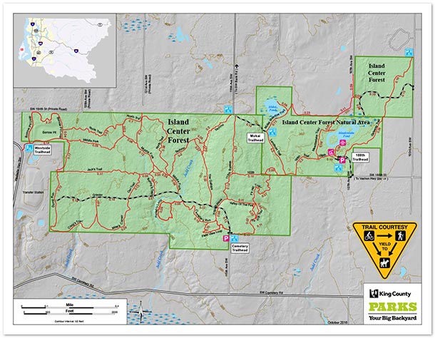
Located in the center of Vashon Island, Island Center Forest is a 440-acre working forest and nature preserve that is managed to demonstrate sustainable forest management while protecting and restoring the health of the site’s habitat. The property is owned and managed by King County Parks in collaboration with community partners who make up the Friends of Island Center Forest, a diverse group that includes the Vashon-Maury Island Land Trust, Vashon Forest Stewards, Vashon–Maury Island Audubon, equestrians and outdoor enthusiasts, among many other community members.
View/download
- Two-page map brochure.
- Designed to print to a letter-size page, two-sided.
- For all devices.
- Folleto de mapas de dos páginas.
- Diseñado para imprimir una pagina de tamaño, por ambos lados.
- Para todos dispositivos.
- One-page geospatial PDF.
- Tap to launch Avenza Maps and load the map.
- For mobile devices only, see below.
- Get the free Avenza Maps app to use geospatial PDFs on your mobile device.
Maury Island Marine Park
Maury Island Marine Park
preview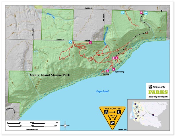
Maury Island Marine Park is located on the east side of Maury Island which is connected to Vashon Island. There is more than one mile of natural shoreline with stunning views of Mount Rainier and the Cascade Mountains. The park is a former gravel mine and contains rare stands of the Pacific madrone tree. The accessible shoreline allows for scuba diving and an excellent beach walk to observe marine life with a salt marsh at the north end.
View/download
- Two-page map brochure.
- Designed to print to a letter-size page, two-sided.
- For all devices.
- Folleto de mapas de dos páginas.
- Diseñado para imprimir una pagina de tamaño, por ambos lados.
- Para todos dispositivos.
- One-page geospatial PDF.
- Tap to launch Avenza Maps and load the map.
- For mobile devices only, see below.
- Get the free Avenza Maps app to use geospatial PDFs on your mobile device.
Moss Lake Natural Area
Moss Lake Natural Area
preview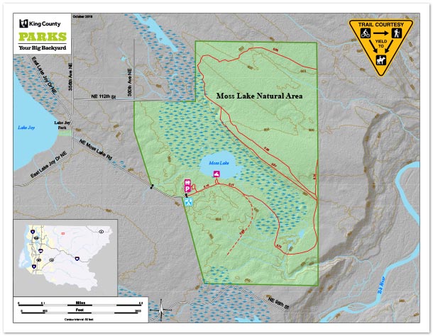
Moss Lake Natural Area is located five miles southeast of Duvall, 3.5 miles northeast of Carnation, and one mile east of Lake Joy in the Cascade foothills. The site comprises 372 acres of high-quality wetland and forested upland habitats. An extensive 150-acre wetland complex encompasses a large sphagnum bog and also features beaver dams and includes a 6.5-acre cattail and spirea-fringed lake. Moss Lake was acquired in three phases from 1990-2002, with the initial 275-acre purchase representing the first major acquisition under the 1989 Open Space Bond approved by King County voters.
View/download
- Two-page map brochure.
- Designed to print to a letter-size page, two-sided.
- For all devices.
- Folleto de mapas de dos páginas.
- Diseñado para imprimir una pagina de tamaño, por ambos lados.
- Para todos dispositivos.
- One-page geospatial PDF.
- Tap to launch Avenza Maps and load the map.
- For mobile devices only, see below.
- Get the free Avenza Maps app to use geospatial PDFs on your mobile device.
Pinnacle Peak Park
Pinnacle Peak Park
preview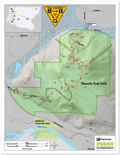
Pinnacle Peak Park is a 375-acre park, surrounding a volcanic cone that rises straight out of the Enumclaw farmlands and towers over the White River. Also known locally as Mount Peak and Mount Pete, Pinnacle Peak is one of the most popular hikes for Enumclaw and south-county families. Trails climb the north and south side 1,000 vertical feet to the top of the 1,800-foot geological knob. Once you get to the top, you will see extruded outcroppings of columnar basalt, concrete footings of an old fire lookout and best of all, spectacular views of Mount Rainier and the White River valley.
View/download
- Two-page map brochure.
- Designed to print to a letter-size page, two-sided.
- For all devices.
- Folleto de mapas de dos páginas.
- Diseñado para imprimir una pagina de tamaño, por ambos lados.
- Para todos dispositivos.
- One-page geospatial PDF.
- Tap to launch Avenza Maps and load the map.
- For mobile devices only, see below.
- Get the free Avenza Maps app to use geospatial PDFs on your mobile device.
Rattlesnake Mountain Scenic Area

Rattlesnake Mountain Scenic Area
preview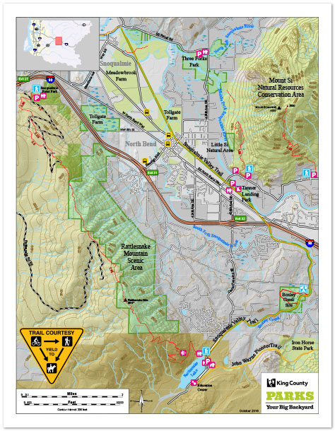
Located just 30 miles east of Seattle near North Bend, the Rattlesnake Mountain Scenic Area is a mountainous ridge along Interstate 90 that offers some of the most scenic hiking in the Cascade foothills. The 10-mile-long hiking trail along the ridge is easily accessible from I-90, provides many opportunities for views of Mount Si, the upper Snoqualmie Valley and the Cascades, and reaches a high-point elevation of 3,500 feet. At the south end, the 1,000-foot-high ledges above Rattlesnake Lake reward hikers with a spectacular view of the Cedar River Watershed.
View/download
- Two-page map brochure.
- Designed to print to a letter-size page, two-sided.
- For all devices.
- Folleto de mapas de dos páginas.
- Diseñado para imprimir una pagina de tamaño, por ambos lados.
- Para todos dispositivos.
- One-page geospatial PDF.
- Tap to launch Avenza Maps and load the map.
- For mobile devices only, see below.
- Get the free Avenza Maps app to use geospatial PDFs on your mobile device.
Ring Hill Forest
Ring Hill Forest
preview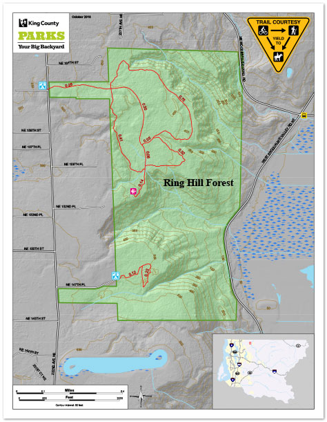
Ring Hill Forest is 320 acres of rural forestland located on the west wall above the Snoqualmie Valley above the Snoqualmie River. The forest slopes from the plateau in the west steeply to the Snoqualmie Valley floor to the east. Ring Hill was acquired to conserve rural forestlands, provide a buffer between rural residential development and agricultural uses in the Snoqualmie Valley, and provide revenue while demonstrating sustainable forestry.
View/download
- Two-page map brochure.
- Designed to print to a letter-size page, two-sided.
- For all devices.
- Folleto de mapas de dos páginas.
- Diseñado para imprimir una pagina de tamaño, por ambos lados.
- Para todos dispositivos.
- One-page geospatial PDF.
- Tap to launch Avenza Maps and load the map.
- For mobile devices only, see below.
- Get the free Avenza Maps app to use geospatial PDFs on your mobile device.
Shinglemill Creek Preserve
Shinglemill Creek Preserve
preview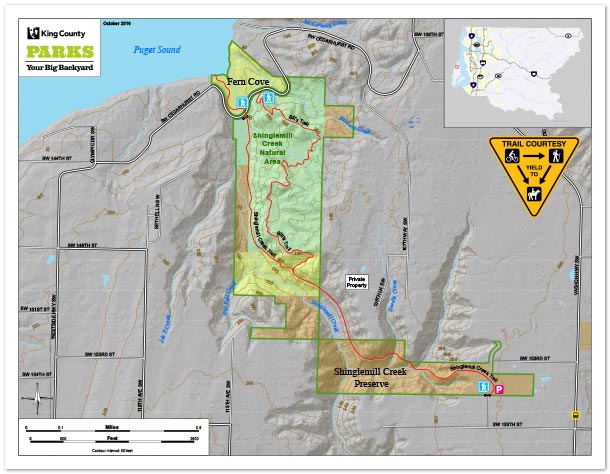
The Shinglemill Creek Preserve is located in the northwest part of Vashon Island and encompasses 168 acres along the lower mainstem of Shinglemill Creek – Vashon’s second-largest creek. Efforts to preserve habitat in the Shinglemill Watershed began in 1994 with the purchase of the historic and iconic Fern Cove, the largest stream delta on Vashon where Shinglemill Creek empties into Colvos Passage on the island’s west shoreline. The lower portion of the Shinglemill Creek trail offers opportunities to watch for coho salmon returning to spawn, typically in November and December after heavy rains. The delta at Fern Cove offers Vashon’s best spot for viewing shorebirds.
View/download
- Two-page map brochure.
- Designed to print to a letter-size page, two-sided.
- For all devices.
- Folleto de mapas de dos páginas.
- Diseñado para imprimir una pagina de tamaño, por ambos lados.
- Para todos dispositivos.
- One-page geospatial PDF.
- Tap to launch Avenza Maps and load the map.
- For mobile devices only, see below.
- Get the free Avenza Maps app to use geospatial PDFs on your mobile device.
Soaring Eagle Regional Park

Soaring Eagle Regional Park
preview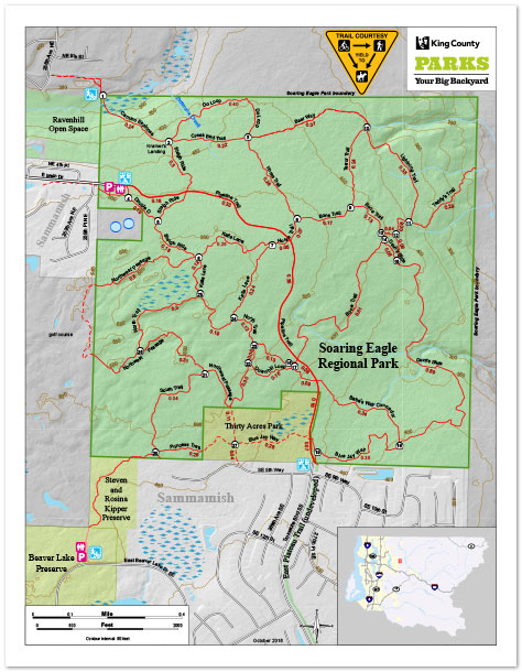
Soaring Eagle Regional Park is 760 acres of mature forests, wetlands, and wildlife habitat. Soaring Eagle sits above Patterson Creek on the edge of the Sammamish Plateau along the western flank of the Snoqualmie River Valley. This natural area provides sanctuary for black bear, bobcat, black tail deer and more than 40 species of birds.
View/download
- Two-page map brochure.
- Designed to print to a letter-size page, two-sided.
- For all devices.
- Folleto de mapas de dos páginas.
- Diseñado para imprimir una pagina de tamaño, por ambos lados.
- Para todos dispositivos.
- One-page geospatial PDF.
- Tap to launch Avenza Maps and load the map.
- For mobile devices only, see below.
- Get the free Avenza Maps app to use geospatial PDFs on your mobile device.
Spring Lake / Lake Desire Park
Spring Lake / Lake Desire Park
preview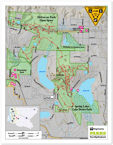
Spring Lake / Lake Desire Park is a 396-acre forested site with a bald rocky outcrop, a bog and 3 miles of trails situated between…Spring Lake and Lake Desire! Echo Mountain is the 900-foot-tall rocky outcrop that provides great views of the two lakes and the Cascade foothills. There is a bog along the west shore of Spring Lake which is also home to unique plants like Labrador tea. This site is connected to more than 1,000 acres of open space which also includes Wetland 14 Natural Area, McGarvey Park Open Space, Petrovitsky Park and nearby Peterson Lake Natural Area and Lake Youngs Park.
View/download
- Two-page map brochure.
- Designed to print to a letter-size page, two-sided.
- For all devices.
- Folleto de mapas de dos páginas.
- Diseñado para imprimir una pagina de tamaño, por ambos lados.
- Para todos dispositivos.
- One-page geospatial PDF.
- Tap to launch Avenza Maps and load the map.
- For mobile devices only, see below.
- Get the free Avenza Maps app to use geospatial PDFs on your mobile device.
Taylor Mountain Forest
Taylor Mountain Forest
preview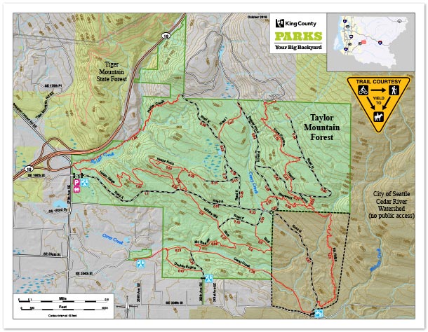
Taylor Mountain Forest is located south and east of Tiger Mountain, south of I-90 and east of SR-18, between the communities of Hobart and North Bend in eastern King County. The 1,924-acre site, which offers sweeping views of Mount Rainier, forested wetlands and meadows of wild flowers, provides an important habitat link between the City of Seattle’s Cedar River Watershed and Tiger Mountain State Forest
View/download
- Two-page map brochure.
- Designed to print to a letter-size page, two-sided.
- For all devices.
- Folleto de mapas de dos páginas.
- Diseñado para imprimir una pagina de tamaño, por ambos lados.
- Para todos dispositivos.
- One-page geospatial PDF.
- Tap to launch Avenza Maps and load the map.
- For mobile devices only, see below.
- Get the free Avenza Maps app to use geospatial PDFs on your mobile device.
Tolt River-John MacDonald Park
Tolt River-John MacDonald Park
preview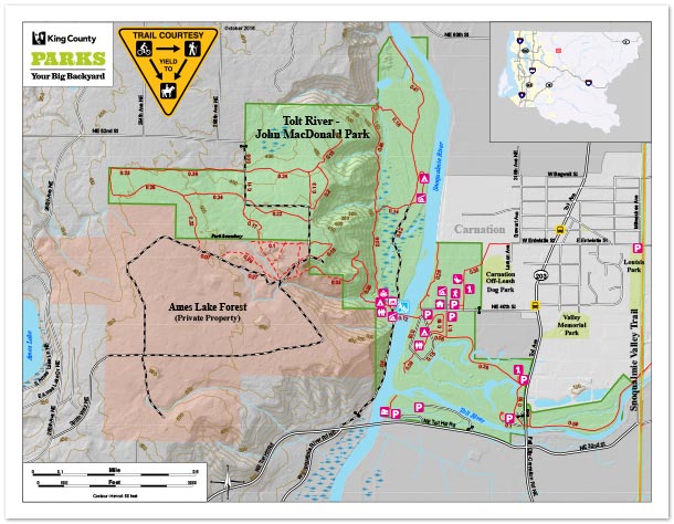
Tolt-MacDonald Park in Carnation is a true recreation destination. Located less than one hour from Seattle, the 574-acre park sits at the confluence of the Snoqualmie and Tolt rivers in the beautiful Snoqualmie Valley. A 500-foot-long suspension footbridge across the Snoqualmie River connects the east and west sides of the park and offers terrific views of the Snoqualmie River and Cascade foothills. You can observe spawning salmon in the river below and eagles and osprey soaring above.
View/download
- Two-page map brochure.
- Designed to print to a letter-size page, two-sided.
- For all devices.
- Folleto de mapas de dos páginas.
- Diseñado para imprimir una pagina de tamaño, por ambos lados.
- Para todos dispositivos.
- One-page geospatial PDF.
- Tap to launch Avenza Maps and load the map.
- For mobile devices only, see below.
- Get the free Avenza Maps app to use geospatial PDFs on your mobile device.
|
|
|
|
|
Print Size: 27 x 18 inches |
||
|
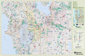
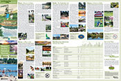
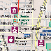
The King County GIS Center, in cooperation with Public Health of Seattle and King County, King County Parks & Recreation, and the cities of Burien, Renton, SeaTac, and Tukwila, produced this map guide to promote recreational activities within this diverse area of King County. KCGIS Center cartographers worked closely with parks staff from the participating agencies to gather information on a variety of recreational resources, such as parks, trails, bike lanes, playgrounds, and community centers. The colorful text and photo layout displays information from each city plus an amenities chart for selected parks and trails Published August 2007. |
||
|
|
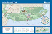
*This map appears here courtesy of the City of Mercer Island. ©2012 City of Mercer Island, All Rights Reserved. Print Size: 17 x 11 inches |
|
|
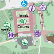
Luther Burbank Park, at the north end of Mercer Island, is highly accessible with its proximity to Interstate 90 freeway exits, the I-90 Regional Trail, the Mercer Island Park & Ride, and Mercer Island's downtown business district. Visitors to the park will find a varied landscape of waterfront vistas, natural areas, and recreation facilities, such as tennis courts, a playground, and picnic areas. Luther Burbank Park is also home to the Mercer Island Parks and Recreation Department offices, and the Mercer Island Community and Event Center is right next door. The Luther Burbank Park map was originally created by the King County Parks & Recreation Division and the King County GIS Center when the park was part of the King County park system. The park is now owned and maintained by the City of Mercer Island Parks and Recreation Department. Working with the City of Mercer Island Parks and Recreation Department and the City of Mercer Island Geographic Information System, the King County GIS Center supplied cartographic services for the map seen here, which was updated and redesigned for placement on several outdoor signs that are situated throughout the park. More (external links) |
||
|
|
Print Size: 17.25 x 11.25 inches |
|
|
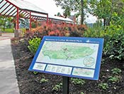
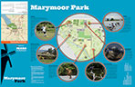
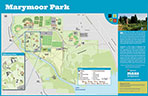
Marymoor Park is the most popular park in the King County Park System. This map depicts the wide variety of athletic, cultural, and recreational facilities and features available for everyday use and for special events within the 642-acre park. Published by the King County Parks and Recreation Division August 2016. See more about Marymoor at King County Parks.
|
||
Regional Trails in King County
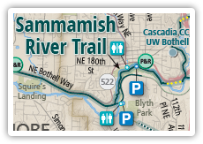
Regional Trails in King County map
preview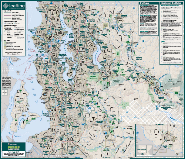
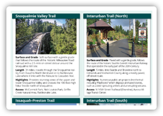
Regional Trails in King County text and photo layout
preview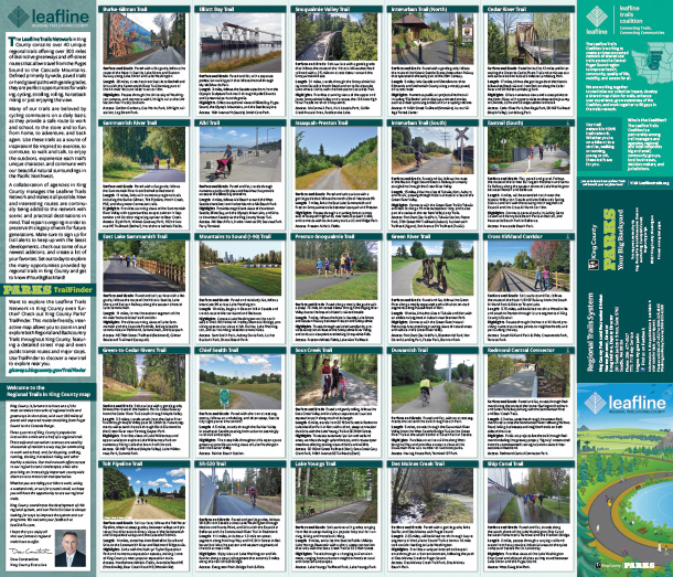
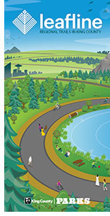
The reverse side of the sheet includes a colorful description in text and photographs of the special characteristics of many of the primary regional trails. Additional text about the Leafline Trails Network is provided to enhance users' access to and enjoyment of the wealth of recreational opportunities provided by the Leafline Regional Trails in King County.
The map was developed, produced, and published by the King County Parks and Recreation Division with cartography and design by Parks and Recreation Division GIS and King County GIS Center Spatial Services.
|
|
Print Size: 18 x 27 inches |
|
|
good quality: 4.95 Mb PDF |
||
|
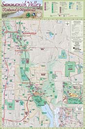
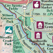
This map guide features recreation amenities for tourists as well as local visitors to the cities of Redmond and Woodinville and the surrounding Sammamish Valley in King County. Concept and coordination of the guide was by the Redmond Tourism Task Force; design and production by the King County GIS Center. The cities of Redmond and Woodinville, and the King County Parks and Recreation Division contributed content. Published February 2005.
|
||
|
|
Print Size: 11 x 17 inches |
|
|
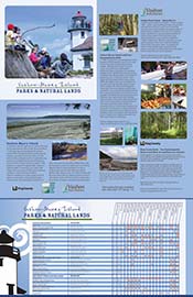
This recreation map and guide was created to promote outdoor opportunities available on Vashon-Maury Island. The map includes topographic detail to help users see the bluffs and stream systems in the area, while the guide includes a recreation chart for parks and facilities, photographs for a number of sites and descriptive text for things to see and do. The project was commissioned by the Vashon Park District and Vashon-Maury Island Land Trust. The map/guide is a joint production of the KCGIS Center, who created the map, and King County Parks, who provided the graphic design and recreation chart for the guide . Revised June 2012.
|
||