
 Translate
Sammamish Watershed
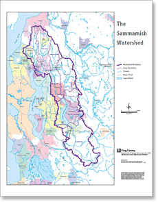
The Sammamish watershed is part of the greater Lake Washington - Cedar River drainage, encompassing the land area in which rainwater drains to Lake Sammamish, Bear Creek, the Sammamish River and out into Lake Washington.
Community service center
Information about King County's satellite offices including the Issaquah Community Center in the Sammamish Watershed. Office address is 5415 220th Ave SE (inside the Issaquah District Court building), phone number 206-477-2169.
Brightwater Education and Community Center
New sustainably-built facility and surrounding park located near Bothell and Woodinville, available host school and community events, indoors or outdoors.
Basin Steward Program
Find out what Water and Land Resources' Basin Steward Program does and how to contact your Basin Stewards.
Surface water and groundwater
Report problems: drainage and water quality
The Restore and Protect Project
Project to identify habitat stressors and recommend restoration and protection actions to improve freshwater quality and aquatic habitat in Puget Sound streams including Stensland and Tibbetts Creeks in the Sammamish Watershed.
Stormwater runoff pollution and how to reduce it
Tips on how to reduce water pollution from home, yard, car, pets and so forth.
Lake Sammamish
Learn about the history of the lake including its past and current pollution problems, kokanee populations and what King County is doing to protect the lake.
- Lake Sammamish water quality data
This page offers an overview of Lake Sammamish water quality issues and provides graphs of water quality data from several sampling locations on the lake, spanning years. Graphs display temperature, dissolved oxygen, pH, conductivity, nitrogen, phosphorus, chlorophyll, bacteria, transparency, and other data.
Swimming beach data
Find information about levels of bacterial pollution and relative health risks at swimming beaches on Lake Washington, Lake Sammamish and other King County lakes.
Pollution monitoring
Rivers and streams: ongoing water quality sampling in Sammamish Watershed streams and rivers. Water quality data are available online for:
- Bear Creek, Cottage Lake Creek and Evans Creek
- Ebright Creek
- Eden (Zuccuse) Creek
- Idylwood Creek
- Issaquah Creek
- Lewis Creek
- Little Bear Creek
- North Creek
- Pine Lake Creek
- Sammamish River
- Swamp Creek
- Tibbetts Creek
Lakes: statistics and water quality
- Allen Lake
- Beaver Lake
- Cottage Lake
- Leota Lake
- Lake McDonald
- Paradise Lake
- Peterson Pond (Swan Lake)
- Pine Lake
- Yellow Lake
- Welcome Lake
Lake Weedwatcher Program
Got a small boat? Interested in saving a lake from the horrors of dense weed infestations?
Endocrine disrupting chemicals in the environment
Learn about these natural and synthetic chemicals flushed daily into our waters, and discover what King County is doing to protect public health and the environment as the science and our understanding of endocrine disruptors develops.
Redmond-Bear Creek Valley Groundwater Management Area
Issaquah Valley Groundwater Management Area
Learn about plans to protect the aquifer in areas spanning the Sammamish watershed including Woodinville, Redmond, Sammamish, Issaquah and areas in between.
Bear Creek Basin Plan
Assessed the condition in Bear Creek drainage basin, predicted future changes based on development pattern and recommended ways to reduce flooding, erosion and sedimentation in the stream and to protect valuable stream, wetland and fishery habitat.
Bear Creek Watershed-Scale Stormwater Plan
Outlines actions and strategies that will restore Bear Creek so that it provides healthy habitat for Chinook salmon and other aquatic species.
Issaquah Creek Basin Current/Future Conditions & Source Identification Report
Analysis of the area draining to Issaquah and Tibbetts Creeks, documenting conditions of surface waters and identifying sources of pollution. Published in 1991.
Issaquah Creek Basin and NonPoint Action Plan
Recommendations to manage flooding, pollution and aquatic habitat in Issaquah Creek and its tributary streams. Published in 1994.
Sediment quality evaluation in Lake Sammamish, Lake Union, and Lake Washington
Report of chemical and biological substances, their distribution and toxicity, and benthic communities at various sample sites.
Major Lakes Continuous Temperature Study
Describes results of continuous temperature monitoring in Lake Washington, Lake Union and Lake Sammamish to help understand aquatic ecosystem response to the changing climate.
Sammamish River Diel pH and DO Study
This study provides data to support the identification of dissolved oxygen, pH and temperature problems in the Sammamish River that affect its aquatic life. The data will also support the development of water quality modeling tools that can be used to evaluate various management options proposed to mitigate problems.
Development of a Water Quality Model of the Sammamish River
Describes the development, modifications, calibration, and testing of the Sammamish River model.
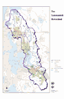
Drainage map displaying streams, lakes, drainage divides, major roads, in King County and Snohomish County portions of the Sammamish River Watershed.
Salmon recovery
Lake Sammamish kokanee
Describes the dwindling population of genetically distinct kokanee in Lake Sammamish and actions that King County and other agencies are doing to protect and restore them.
Lake Sammamish Urban Wildlife Refuge Partnership
Extensive effort to support conservation of fish and wildlife in the Sammamish Basin, and contribute to the quality of life for current residents and future generations.
Sammamish kokanee videos
Kokanee releases and returns on creeks along Lake Sammamish.
Lake Washington, Cedar River and Sammamish (WRIA 8) salmon recovery
This site provides information about the recovery of threatened salmon species in the Sammamish, Lake Washington, and Cedar River drainage area including an overview of the planning process, scientific information, and meeting records. We welcome your participation.
Greening your Shoreline
References and recipes for lakeshore property owners on Lake Sammamish and Lake Washington can use to improve shorelines for people and salmon.
Predicting Climate Change Effects on Kokanee Habitat Suitability in Lake Sammamish
Report on the application of 2-D and 3-D temperature models of Lake Sammamish to evaluate future climate change impacts on kokanee habitat.
Water Resource Inventory Area (WRIA) 8 plans, studies and maps
- Salmon and People Living Together: Implementation Progress Report 2006-2015
- Final WRIA 8 chinook salmon conservation plan
Cedar River, Sammamish, Lake Washington - Chinook Conservation Plan Implementation Progress Report, 2011
State of the Chinook salmon populations, the watershed, and efforts to implement the WRIA 8 Chinook Conservation Plan during the first five years (2005-2010). - WRIA 8 Land Cover Change Analysis, 2011 (2.3 Mb Acrobatpdf)
Known freshwater distribution of salmon and trout
Draft maps showing chinook, coho, cutthroat trout, kokanee, sockeye, and steelhead distribution in the greater Lake Washington watershed (WRIA 8), based on the collective personal knowledge of resource professionals and data gathered from published and unpublished databases.
Flooding and hydrology
Issaquah Creek flood information
View real-time gage data and map for Issaquah Creek and learn about expected conditions at various flood phases.
Hydrologic gage data map
Look up detailed gaging station data for creeks in the region.
Lake Sammamish flooding frequently asked questions (FAQs)
Find answers to questions about flooding near Lake Sammamish.
Wastewater treatment
Brightwater Treatment Plant
Regional clean water factory that treats wastewater from homes, schools, businesses and industries in north King County and south Snohomish County. The plant design integrates landscape, architecture, wildlife habitat, engineering, art, and education.
Recreation and appreciation
Swimming beach data - water temperature, bacteria and algal toxin measurements
- Beaver Lake Beach
- Idylwood Beach (Lake Sammamish)
- Lake Sammamish Beach
- Pine Lake
King County natural areas:
Look up individual properties protected in King County's open space system for their ecological and working resource values. The natural lands site provides addresses, pictures, location maps and rules for public use:
- Bassett Pond Natural Area
- Cold Creek and Bassett Pond Natural Areas
- Evans Creek Natural Area
- Issaquah Creek Park Natural Area
- Kathyrn C. Lewis Natural Area
- Log Cabin Reach Natural Area
- Lower Bear Creek Natural Area
- Taylor Mountain Forest
Sammamish Valley tourism & recreation map guide
Outdoor recreation opportunities and points of interest for residents and visitors around Redmond and Woodinville, Washington.
East Lake Sammamish Trail
This scenic and safe regional trail hugs Lake Sammamish and runs from the city of Issaquah to Redmond, connecting Lake Sammamish State Park at the south end with King County's Marymoor Park at the north end of Lake Sammamish.
Burke-Gilman Trail
Sammamish River Trail
King County's beloved regional trail hugs Lake Washington and the Sammamish River to provide a link between the Cities of Seattle, Lake Forest Park, Bothell, Redmond and the crown jewel of our parks system, Marymoor Park.
Marymoor Park
The largest and most diverse destination park in King County's portfolio of Parks. Provides hundreds of acres of nature and offers a wide variety of recreation options including birdwatching, rock climbing, fishing, off-leash dog walking, bike racing, team sports, outdoor concerts and movies and just being.
Fishing regulations and seasons (external link)
Washington Dept. of Fish and Wildlife fishing rules for Washington State including Sammamish River, Lake Sammamish and their tributaries, and lakes within the watershed.
Lake Shorelines, Life on the Edge Video Series
Watch a video that describes lakes in King County and how residents value them, with ideas that shoreline landowners may like to apply to help preserve the quality of lakes and lake ecosystems.
Lands
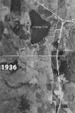
Historic and recent aerial photographs
Aerial photos from the 1930's, 1970's, and 1990's illustrating growth around Cottage Lake, among other areas in King County.
Quality assurance project plan for regulatory effectiveness monitoring for developing rural areas
Framework to monitor and evaluate land use regulations to help ensure their effectiveness, using indicators for hydrology, water quality, biology, and stream complexity.
Noxious weed infestation map
Interactive map showing location of regulated noxious weed infestations.
Agriculture in King County, Washington
Comprehensive information related to agriculture in King County including parts of the Sammamish Watershed.
- FARMS Report - Future of Agriculture Realizing Meaningful Solutions
Report describes the findings of a study that determining what measures King County and other agencies should take to ensure the continued success of local agriculture.
Documents
Related information
- King County watersheds map
- Animals, plants and habitat
- Water and land services
- Environmental data and trends
- Environmental stewardship
- King County environment
Related agencies
- Dept. of Natural Resources and Parks
- Water and Land Resources Division
- Wastewater Treatment Division
- Parks and Recreation Division
News and announcements
Nov. 15, 2023
External article, Seattle Times
King County’s urban streams are showing signs of improving health. Just ask the bugs.
Oct. 11, 2023
Now open! King County completes East Lake Sammamish Trail, contributing to the 44-mile Locks to Lake Corridor
Jun. 2, 2023
King County files federal lawsuit against PFAS manufacturers for damage caused by toxic ‘forever chemicals’

The right investments at the right time in the right places.