
 Translate
King County watershed information
This page provides watershed-related information that spans the county or multiple watersheds within it. To find information about a specific watershed, river or stream, use King County's watershed, river and stream map to find it.
 Watershed related resources
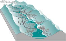
Introduction to watersheds
A general overview of watersheds, what they are and why they are valuable.
King County basin stewards
Basin stewards are watershed experts who help citizens by solving watershed related problems and providing answers to their questions. Basin stewards respond to inquiries, coordinate help among diverse public agencies, facilitate watershed improvement projects, provide assistance to monitoring programs, and provide public education.
Streams monitoring data
Keeping watch for pollution in King County streams.
Critical Areas Package - CAO Resources
Critical Areas Ordinance fact sheet: aquatic areas (Acrobat)
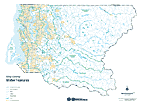
This color map includes cities as of April, 2000, lakes, rivers, streams, watersheds and sub-basins. Map size will fit 11" x 17" with landscape orientation, or may be plotted at a 300% enlargement to fit 36" x 48" (E size). File format is Adobe Acrobat version 3. File size is 802 Kb. For more maps, see Natural Resources reference maps.
Noxious weed infestations map
Interactive map showing location of regulated noxious weed infestations.
Natural resource lands
Look up individual properties protected by King County as open space for their ecological and working resource values. The natural lands site also provides rules on public use and plans describing how properties will be managed.
Large wood in King County rivers
Learn how King County manages large wood in streams for public safety and where projects are planned.
Watershed-related projects and programs
Recycled water
Learn about reclaimed water, which reduces dependence on fresh water sources and is useful for irrigation, hvac systems and industrial processes.
Shoreline Management Program
Learn about King County's program to protect shorelines, promote public access, and establish priorities for shoreline uses for the county's large lakes, rivers and Puget Sound.
Normative flow studies
Find out about this Water and Land Resources project that's designed to enhance our knowledge of how river and stream flows affect salmon survival and ecosystem health, for use in managing stormwater, flood hazards and water reuse.
Watershed planning for salmon habitat
Learn about the plans and accomplishments these regional partnerships have achieved in salmon habitat conservation and restoration, promoting the local survival of threatened salmon species.
Current use taxation programs
Public Benefit Rating System & Timber Land Programs.
Transfer of Development Rights (TDR) Program
Sell rights to develop to apply to locations suitable for denser development and protect special and rare places.
Stormwater facilities, projects and studies - interactive map
Note: turn off your popup blocker - this link will open a new browser window
Zoom in to view the full set of GIS layers including the regional, commercial and residential stormwater facilities, neighborhood drainage projects, stormwater studies, and aerial imagery among other things. Viewing information about individual map features may take some practice: choose the "active" (or queryable) map layer from the layers list, select the 
Hydrography - interactive map
Note: turn off your popup blocker - this link will open a new browser window
Zoom in to view and query GIS datasets including lakes and streams in King County, drainage areas, King County wetlands inventory, National wetlands inventory, and display aerial photos and USGS topographic map images.
Groundwater management
Learn what Water and Land Resources has accomplished and plans to accomplish to protect groundwater resources in King County.
Environmental Laboratory
Collects samples from rivers, lakes, marine waters, biosolids application sites, industries and wastewater treatment plants, and analyzes samples in one of several labs including trace metals, organics, conventionals, microbiology and aquatic toxicology labs.
River and Floodplain Section
A summary of the roles and responsibilities of King County's flood hazard reduction services group, including river facility maintenance, managing emergency flood response, elevating or relocating of flood-prone structures, acquiring flood prone lands; flood hazard mapping and technical assistance to cities and individual landowners, and flood hazard education. Also, see flooding services and information.

We count on bugs to measure stream health. The bug page provides info about benthic macroinvertebrates including caddis, mayflies, stoneflies, and other aquatic creatures, and how these bugs are used to measure pollution levels, nutrients, and other factors of ecosystem health n King County streams.
Puget Sound stream benthos (external)
Look up data, maps, and analysis of benthic macroinvertebrate data from King County (WLRD, Roads and DDES) and other participating agencies: Redmond, Seattle, Kirkland, Lake Forest Park, and Clallam County.
Watershed documents
Status of Biodiversity in King County
This report is an assessment of King County biodiversity. It describes biodiversity in King County and has maps of landscape diversity and rare, threatened, and endangered plant and animal species.
Critical Areas Ordinance (CAO) monitoring
Includes the CAO monitoring study whose purpose is to develop an approach for effectiveness monitoring and apply that approach to evaluating the effectiveness of current land use regulations to inform the 2012 Growth Management Act (GMA) regulatory review.
Literature Review and Recommended Sampling Protocol for Bull Trout in King County
This technical report contains a summary of the available information (maps, sampling areas, etc.) regarding bull trout (Salvelinus confluentus) distribution and life history strategies within King County.
King County National Flood Insurance Program Biological Opinion Compliance Submittal and Programmatic Habitat Assessment
King County submitted a programmatic habitat assessment of current and anticipated future impacts of regulated land-use upon Chinook and steelhead salmon and their habitats. This assessment conducted an in-depth analysis of how numerous King County regulations manage and restrict the potential for further land development within the 100-year floodplain across the county, while also promoting restoration of some natural floodplain functions and processes in some watersheds of the county. FEMA determined that the assessment was able to demonstrate that King County implements a floodplain development program that is compliant with the requirements of the Endangered Species Act (ESA).
Climate Change Impacts on River Flooding
Study looks into rainfall and river flow data throughout King County to determine whether large storm events and large flooding events are happening more often than they used to.