
 Translate
Property research and maps
King County offers several different mapping programs to help you understand your property. See below for more information.
|
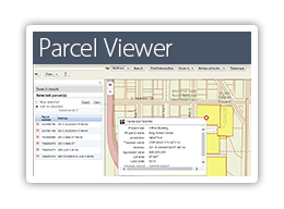
For information on the King County Assessor's eReal Property report and Districts and Developments Conditions report. |
 |
|
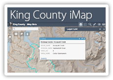
View King County's spatial information (GIS data and images) on an interactive map. Use this map and the available layers to learn about your property. |
 |
|
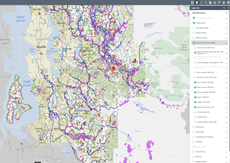
View potential landslide hazard or steep slope areas which may be present on or around your property. |
 |
Helpful tools and resources
Research your property
-
Property research
To better understand your property, do your research early. Check the jurisdiction and zoning to be sure it’s in unincorporated King County (outside city limits) and understand what building or land use options you have based on your zoning. Start with our online tools to get the information you need for your application.
King County property report, eReal property with the Department of Assessments
Make note of any special conditions on your property, such as...
- Critical areas
- Established clearing limits
- Flood zones
- Historically sensitive areas
- Setback areas
- Shorelines
- Steep slopes
- Total impervious lot coverage
- Wetlands
Confirm your zoning when doing research and understand what building or land use options you have by referencing:
-
Prepare
Get all application materials ready for electronic submittal for a complete application package.
- Check submittal requirements and application forms on our Permit forms, applications and resources page.
You can also go through the application steps on MyBuildingPermit.com. After creating an account, selecting your project type and providing location details, a list of required documents for your project and permit type will be provided. You do not need to submit the application until you are ready.
Note: Incorrect or incomplete application submittals will not be accepted and will delay your application process.
Watch our video
Learn how to research a property using King County's iMap service.
Property detail
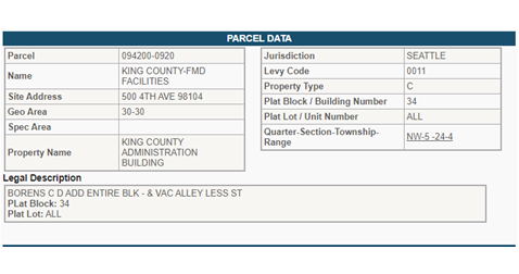
Visit the Department of Assessments eReal Property portal and select "Property Detail" to get information about your property such as:
|
Parcel data This is where you can confirm jurisdiction, property owner name, and legal description. |
Example
|
|
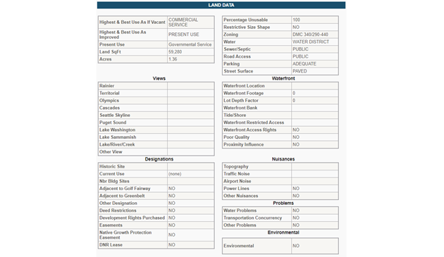
Land data Provides information about zoning, land total size, present use, water, sewer and/or septic details, and more. |
Example
|
|
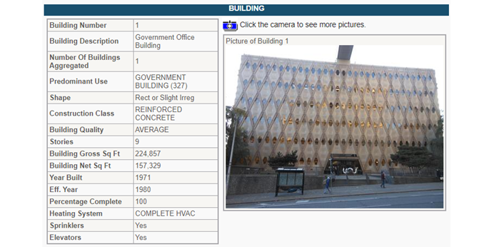
Building information This section is where you can confirm the number of buildings on record, their square footage and age. |
Example
|
Zoning codes
County code sections are summarized below to help guide you to information about the legal use of your property. If you need more detailed or specific assistance after reviewing this information, we strongly recommend working with a professional consultant who is familiar with our local zoning rules and procedures. They can provide a more in-depth understanding of the code and advice tailored to your specific property.
Access King County Zoning Codes and other code information to learn more about your property such as setbacks, allowed and permitted uses, and more.
King County code, Tile 21A Zoning
Section 21A.08
This part of the code provides information about what types of structures and uses are permitted on a property based on its zoning designation. Here's an overview of some information you can find in this section of code:
- Permitted Uses: The code provides a detailed list of residential land uses (single-family homes, apartments, townhouses, mobile home parks, etc.) and whether they are permitted in different zoning areas.
- Conditional and Special Uses: There are some uses that may be allowed under certain conditions or special circumstances. For example, an apartment or a townhouse might be allowed in a certain zone, but only if specific conditions are met.
- Accessory Uses: The code specifies what types of accessory uses (additional activities or structures that are secondary to the main use of the property, such as home offices or accessory dwelling units) are allowed.
- Temporary Lodging: Information about temporary lodging options like hotels, motels, or bed and breakfast establishments is also provided.
- Development Conditions: The code outlines specific conditions that must be met for certain types of development. These could include restrictions on site disturbance, requirements for accessory dwelling units, limitations on mobile home parks in certain zones, and more.
- Prohibitions: The code also specifies what is not allowed. For example, any accessory use not expressly permitted by this chapter or by the director is prohibited.
- And more...
Section 21A.12
This part of the code provides detailed regulations on the density and dimensions of structures that can be built in different types of zones. Some of the topics covered in this section are:
- Densities and dimensions: This table provides detailed information on the allowed density and dimension standards for different types of residential and rural zones. The table includes information on things like base density, maximum density, minimum density, minimum lot area, minimum lot width, minimum street setback, minimum interior setback, base height, maximum height, and maximum impervious surface.
- Interpretation of tables: Which show how many homes can be built in an area, how big the buildings can be, and how much space needs to be left open.
- Measurement Methods: This section likely provides detailed instructions on how to measure lot size, building height, setbacks, and other important dimensions.
- Calculations: Provides details on how to calculate the allowable dwelling units, lots, or floor area based on the site area used for base density and maximum density floor area calculations.
- Setbacks: Provides specific rules for setbacks for specific buildings or uses, from regional utility corridors, alleys, etc.
- Height limits: Provides details on exceptions to height limits and specific height limits near major airports.
- Nonresidential and residential zones: Provides rules for nonresidential land use in residential zones.
- Joint use driveway and easement width: Provides rules for driveways that are shared by multiple properties and the required width of easements.
- And more...
By understanding the regulations in this section of the code, a property owner can determine what they are allowed to build on their property, under what conditions, and what uses they can make of their property. If you are unsure, we recommend that hire a consultant to ensure correct interpretations of the code.
Districts and developments report
The King County GIS Center provides comprehensive parcel reports, such as the Districts and Development Conditions Report which includes district, zoning, and development information for specific locations in King County.
You can find information such as electoral, planning, and critical areas designations, as well as access to related resources such as permit applications, property tax information, and more.