Translate
Landslide hazards along King County river corridors
Learn about the locations and types of landslides that can occur in King County river corridors. Understanding where landslides have happened in the past and the different types of landslides can help you be prepared.
What are landslide hazards?
Landslides can happen quickly and with little warning. Gravity acting on a slope that is too steep is the main reason for a landslide. Other factors that can contribute to a landslide include:
- erosion patterns,
- water saturation from heavy rain or snowmelt,
- earthquakes,
- volcanic eruptions,
- added weight from fill and man-made structures on weak slopes.
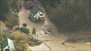
Earth and rocks that have been moved by a landslide can become saturated with water and develop into a debris flow or mud flow. The resulting mixture of rock and mud may pick up more debris, and the landslide body can block bridges and tributaries that may cause flooding along or beside its path. This flooding can cause even more damage than the initial landslide. It is very difficult to predict how far a landslide mass will travel once it has started and the landslide deposit also can cause damage.
Areas where a landslide has happened before can be more likely to experience another landslide in the future. Knowing where landslides have occurred in King County is a valuable tool for future planning. Landslide prevention requires responsible engineering, land management, and communities working together.
What is the risk of landslides in King County?
The risk of landslides in King County varies. Places where landslides have occurred in the past are more likely to experience a landslide again. Visit the interactive landslide hazards map to see the locations of past and potential future landslides in King County.
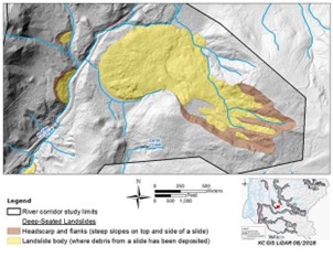
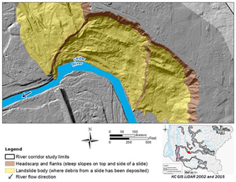
In 2016, the King County Department of Natural Resources and Parks Water and Land Resources Division River and Floodplain Management Section completed a special landslide investigation in coordination with the King County Department of Permitting and Environmental Review to understand what areas along King County river corridors are most vulnerable to landslides. This study was done in response to the Oso landslide that blocked the South Fork Stillaguamish River. For in-depth information about the study, you can read the full report: Mapping of Potential Landslide Hazards along the River Corridors of King County, Washington.
Learn how to protect your home and property
A Homeowner’s Guide to Landslides for Washington and Oregon
Created in cooperation with the Oregon Department of Geology and Mineral Industries and the Washington State Department of Natural Resources, this guide provides information that can help you protect your home and community from landslide hazards.
There are five different types of landslides that occur in King County: shallow debris slides, deep seated landslides, debris flows and floods, depositional fans, and rock falls and avalanches. Each of these types of landslides has different physical characteristics and happens in different places. Understanding the types of landslides that can happen in your area can help keep your family and property safe because you will be better able to identify the signs of an impending landslide and how it might travel through your area. Learn about the three most common types of landslides below.
What types of landslides are most common in King County?
Shallow debris slides
Shallow debris slides (also known as shallow landslides) are common in the Puget Lowland and Cascade Mountains. Shallow debris slides occur when a thin layer of soil, generally less than 10 feet deep, slides down the surface of stronger material underneath it, such as bedrock or compacted glacial sediments. Rain and flooding are common triggers of shallow debris slides. Human activity such as logging and construction can also cause shallow debris slides when done without care for the environment.
Although small in scale, shallow debris slides can occur on almost any steep slope anywhere on the landscape including mountains or lowlands. These landslides don't travel very far unless they transition into a more dangerous debris flow. The most dangerous aspects of a shallow debris slide are the logs and other large materials they can carry.
Deep-seated landslides
Compared to shallow debris slides, deep-seated landslides extend through the overlying soil into underlying bedrock that is usually weak or broken. These types of slides are often slow moving and can cover large areas and devastate infrastructure and property. Much like shallow debris slides, deep-seated landslides are usually caused by long-duration, large rainfall events.
Many deep-seated landslides share characteristics such as a steep incline at the top and a distinct deposit of displaced debris at the bottom. Over time, erosion evens out the slope of a deep-seated landslide, making very old landslides hard to distinguish from the surrounding topography.
Debris flows and floods
Debris flows and debris floods occur when landslide debris moves in a fluid state down a channel. They can travel a long distance from the point of origin.
Debris flows often begin as debris slides on steep slopes. If the soil, rocks, and plant material of a debris slide mix with enough water from a stream or flood, it can liquefy and become a debris flow. A debris flow can move and carry boulders, plants, and trees along with it.
In the Puget Lowland, debris flows can also start when there is a sudden high flow of water in a steep channel. One common example is a sudden breach of a beaver dam that was holding back a large amount of water. This can result in a much bigger flow than floods caused by rain or snowmelt. This type of discharge often causes dramatic erosion and channel incision. Channel incision is the deepening of a river because the sediment at the bottom of the river is washed away.
Debris floods have a higher water content than debris flows. Debris floods move smaller-sized sediment, carry less organic debris, and pose less of a safety risk as compared with debris flows. Debris floods can join with existing waterways and transition into conventional fluvial flooding. Fluvial flooding is when a river or lake overflows onto neighboring land.
Depositional fans
Depositional fans are the accumulation of sediment in a characteristic fan shape at the bottom of steep channels. These fans form when sediment moving quickly down a steep channel slows down because the channel hits a plateau or valley floor. Fans generally form over time as a result of repeated debris flows.
An area with a depositional fan is often an indicator that the area will flood again. A review of sites with known debris flows or debris floods suggests that they share some characteristics, including the presence of depositional fans:
- All recent incidents of debris flows or floods were from ravines with steep side slopes;
- All debris flows or floods emptied into well-defined, preexisting fans, and a number of recent cases were the result of failure of an upstream beaver dam;
- Where the channel gradient above the fan was steep, in excess of a 15 percent slope, the discharge was in the form of a debris flow; and
- Where the channel gradient was less than a 15 percent slope, the discharge took the form of a debris flood.
These observations are based on a small number of recent incidents, which is not enough to develop robust screening criteria. Based on the characteristics above, DNRP geologists used LiDAR imagery and closely spaced contour lines to map depositional fans in the Puget Lowland areas.
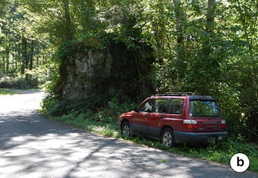
Rock falls and rock avalanches
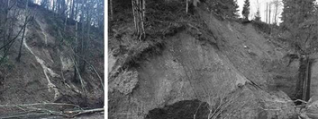
A rock fall is a type of landslide that occurs in bedrock where one or more rocks break away from the cliff and fall down into the valley below. Tumbling boulders falling from a cliff face move fast and can destroy almost anything in their path. Earthquakes, freeze-thaw cycles, or severe weather can all start a rock fall.
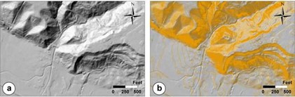
In alpine settings, cliffs are usually on the upper slopes of a mountain with a talus below that extends to the base of the mountain (see figure "a" below). A talus is a slope made from the accumulation of rock debris. Rocks and boulders that fall from the cliffs generally don’t extend past the edge of the talus, but those that do can be dangerous to humans and property (see figure "b" below).
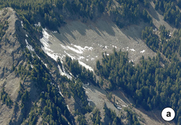
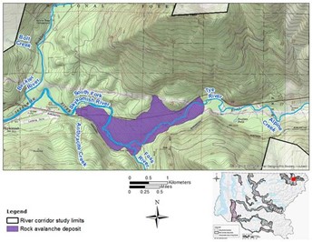
A rock avalanche is a landslide where an entire bedrock hillslope fails and the dislodged mass of earth cascades into the valley below. Rock avalanches move at very high speeds and can be massive in size. They can extend farther from the base of slope and cover a much larger area compared with individual rock falls.
The image below is an example of a rock avalanche deposit mapped in the South Fork Skykomish River valley. Maps like this can be used to predict where a rock avalanche may occur again in the future.