
 Translate
Flooding in the Sammamish watershed
About flooding in the Sammamish watershed
The Sammamish watershed is the area of land that drains snowmelt and rainwater into Lake Sammamish and then out to Lake Washington. Starting at the mouth and moving upstream, the Sammamish River flows 14 miles from Lake Washington to Lake Sammamish. It passes through the cities of Kenmore, Bothell, Woodinville, and Redmond.
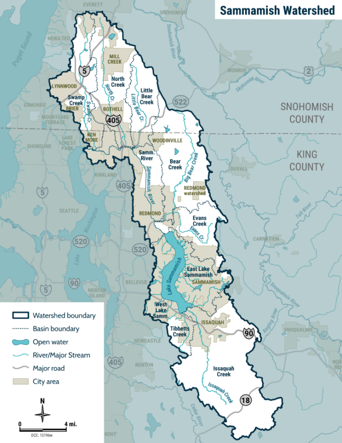
The main sources of the Sammamish River include Lake Sammamish and the Bear, Little Bear, North, and Swamp creeks. Much of the wide floodplain area in the middle and upper portions of the river is in unincorporated King County and protected for farming by the Farmland Preservation Program.
The Issaquah, Tibbetts, and Laughing Jacobs creeks all flow into Lake Sammamish.
Flood risks in the watershed
- Issaquah Creek flows through the City of Issaquah and creates an urban flood hazard area there.
- Flooding of recreational infrastructure and landscaping occurs regularly around Lake Sammamish. Find more information at Lake Sammamish flooding frequently asked questions (FAQs).
- In Redmond, Sammamish River flooding can impact the accessibility of Northeast 95th Street and low areas on the Sammamish River Trail. Flooding can also have a severe impact on stormwater and water quality infrastructure, at times backwatering into facilities.
- In the Agricultural Production District between Redmond and Woodinville, farmland flooding can occur when the river elevation is high and upland stormwater cannot drain effectively.
- From Woodinville downstream to Lake Washington, the river generally stays within its banks.
Flood infrastructure in the watershed
The entire Sammamish River is part of a flood control project completed by the U.S. Army Corps of Engineers in 1966. The project straightened the previously meandering river channel. King County was a partner and accepted responsibility for long-term maintenance of the project. The project was designed to provide agricultural crop protection after March 1.
The project includes a transition zone that connects Lake Sammamish to the Sammamish River. It is designed to control spring and summer outflows from the lake. The transition zone includes a low concrete dam, called a weir, that raises the level of water upstream. Immediately downstream of the weir is a steep 1,400-foot section armored with rock that provides the hydraulic control for the lake at higher flows. Every summer, King County, as a service provider to the King County Flood Control District performs annual maintenance of vegetation in the transition zone, to ensure adequate conveyance.
King County, as service provider to the King County Flood Control District, monitors and maintains revetments along Issaquah Creek and two of its tributaries: Fifteen-Mile Creek and Holder Creek. A revetment is a structure built along a riverbank to prevent erosion.
Learn about the history of the Sammamish River
Visit the Sammamish River StoryMap for an interactive history experienceThe importance of healthy floodplains
Kokanee salmon, which were once abundant in Lake Sammamish, are nearly gone due to land use changes and their impact on fish habitat. Issaquah Creek is one of the highest priority habitats for Chinook salmon protection and restoration. Carey Creek and Holder Creek, which flow into Issaquah Creek, also provide excellent salmon habitat.
Changing the natural or built environment can affect fish habitat, including water quality and temperature. We consider potential impacts to these species when designing flood risk reduction projects.
Resources
Resources by city
City of Bothell rain and flooding information
City of Issaquah Flood Preparedness website
City of Kenmore Emergency Preparedness
City of Redmond Flood Preparedness website
City of Woodinville Frequently Flood Areas Map
Check your river gage data.
A river gage station is a location where hydrologists, or people who study the flow of water, gather information such as the height and depth of a river and the speed of the water flow.
- Issaquah Creek Gage Data
- Issaquah Creek near Hobart Gage Data
- Issaquah Creek Mouth near Issaquah Gage Data
Additional resources
Learn how to prepare for a flood
Free sandbag materials are available at Marymoor Park in Redmond
Want to learn more about creating a flood resilient future in your watershed?
Learn about the Sammamish River Capital Investment Strategy
The Cities of Bothell, Woodinville, and Redmond have all invested in restoration projects to improve the ecological and aesthetic conditions along the Sammamish River. Many of the city parks along the river have been improved, including replanting of the riverbanks. Several older bridges have been replaced and others have been newly constructed in recent years. Each new bridge has been designed to divert floodwater away from developed areas.
Flooding along Issaquah Creek in February 2020 caused significant damage to nearby homes and public infrastructure. In response, King County, as service provider to the King County Flood Control District, is working to improve flood resilience with new technical analyses, infrastructure projects and repairs. King County is partnering closely with the City of Issaquah on technical analyses and projects within the City limits.
Projects and studies
Current projects and studies
- Momb Revetment Repair project (Issaquah Creek)
- Willowmoor Floodplain Restoration Project (near Marymoor Park in Redmond)
Key reports, studies, surveys
Mapping of Potential Landslide Hazards along River Corridors of King County, Washington, 2016
King County Flood Control District’s 2019-2020 Flood Season Report
Issaquah Creek Basin, Baseline Conditions Assessment Report, 2021
Recently completed projects
Irwin Right Bank Revetment Repair 2022 (located near Issaquah Hobart Road Southeast)
- Flooding in February 2020 on Issaquah Creek damaged the revetment creating a flood and safety risk to three private residences and the heavily used Issaquah Hobart Road Southeast. The revetment was repaired to reduce the risk of potential failure.
Sammamish Bank Repairs 2018 (located in Bothell near the Interstate 405 overpass)
- Riverbank damage in two locations threatened to impact the Sammamish River Trail. Repairs were made to stabilize the riverbank and add native plants. This helped provide greater safety for the trail, which is popular for walking, running and cycling.