
 Translate
McElhoe Pearson Restoration Project
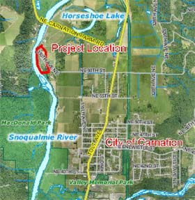
Large vicinity map (Acrobat pdf)
The McElhoe Pearson Restoration Project was completed in 2012. The project site is located north of the City of Carnation in unincorporated King County. The project involved restoring the Snoqualmie River channel and reconnecting a high quality wetland to provide off-channel rearing and flood refuge habitat for juvenile salmon.
King County Department of Natural Resources and Parks improved floodplain habitat by breaching a section of an existing levee within a King County-owned parcel. The project restored a surface water connection between the Snoqualmie River and a portion of its historic floodplain that was isolated for over 50 years by a large flood protection levee. The isolated floodplain area contained a high quality wetland that was inaccessible to juvenile salmonids except during very large flood events (>60,000 CFS at Carnation). The modifications restored 500 feet of channel that connects the Snoqualmie River to the wetland. This area provides approximately two acres of enhanced off-channel rearing and flood refuge habitat for juvenile salmon within the Ordinary High Water Mark (OHWM) of the Snoqualmie River. Removing a portion of the McElhoe Pearson Levee addressed one of the primary limiting habitat conditions (off-channel rearing and refuge habitat) in the highest priority reach along the Snoqualmie River as identified in the Snohomish River Basin Salmon Conservation Plan (external link).
The specific location of the McElhoe Pearson Restoration Project is the right (east) bank of the Snoqualmie River near River Mile 23. It is north of the City of Carnation in unincorporated King County in Sections 9 and 16 of Township 25 North, Range 7 East; Thomas Brothers’ Map page 539, C6 (see attached Vicinity Map). It is located within the 100-year floodplain of the Snoqualmie River and within the Snoqualmie Basin (WRIA 7). The two King County owned parcels (0925079032 and 1625079008) are located between the Snoqualmie River and 310th Ave NE/NE 60th Street. They are separated from the river by a flood control levee. The adjacent private parcel (0925079014) is located northeast of 310th Ave NE/NE 60th Street.
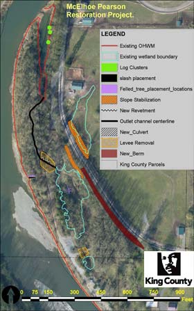
Large concept map (Acrobat pdf)
Project outcomes
The project completed the following actions (See Figure and 100 percent Plan Set below):
- Breached a levee and excavated a 500-foot-long outlet channel that connected the Snoqualmie River to an existing wetland, thus increasing off-channel rearing and flood refuge habitat for juvenile salmon;
- Excavated a small area (0.031 acres) within the existing wetland to provide deeper aquatic habitat for juvenile salmon during the periods of low flow;
- Excavated a small area (0.06 acres) adjacent to the wetland to expand the wetland area;
- Planted or maintained approximately one acre of the riparian area to establish native plants;
- Installed three log clusters within the existing backwater area to improve rearing habitat;
- Installed a 24-inch diameter x 65’ long culvert to connect the upper and lower wetland areas;
- Installed large rock along a critical section (~240’) of the eastern slope of the 310th Ave NE to maintain stability of the road prism in that area; and
- Installed a shallow gravel and rock berm along the western edge of 310th Ave NE to maintain the existing level of flood protection to property and infrastructure.
Project documents
McElhoe-Pearson Habitat Restoration Project documents are provided in Adobe Acrobat format. For help using Acrobat files, please visit our Acrobat help page.
- Year 5 (2017) Monitoring Report, McElhoe-Pearson Off-Channel and Floodplain Reconnection Project
- SEPA Determination of Non-Significance
- SEPA Environmental Checklist
- 100% plan set (9.2 Mb)
- Large wood safety checklist (379 Kb)
For more information about the McElhoe Pearson Restoration Project, please contact Fauna Nopp, Project Manager, King County Rural and Regional Services Section.