
 Translate
River and Floodplain Management Section
Restoring rivers and reducing flood risks
News and features
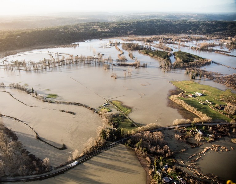
- The first step in preparing for flood season is understanding your flood risk. Check any address in the King County flood map to see if it is located in the FEMA 100-year floodplain.
Capital Improvement Projects
Projects are designed to reduce risks to public health and safety, protect infrastructure and provide habitat components in compliance with natural resource regulations.
Flood Warning System - The system is designed to warn and provide information to residents and agencies about impending floodwaters on major rivers so they can take action and prepare themselves before serious flooding occurs. The web site links to real-time river gage data and describes the local flooding homeowners can expect at different flood phases based on past flood events.
Home Buyouts and Elevations in flood prone areas - The home elevation program assists property owners with the costs of raising the finished floor of a home above the 100-year elevation, substantially reducing the threat of future damage. Home buyouts provide a permanent solution to the risks and damages of repetitive flooding.
Mapping, Floodplain Mapping and Channel Migration Hazard Mapping - These hazard areas are regulated to limit or prevent at-risk development. Since 1991, updated flood boundaries have been mapped on nearly 80 miles of river, and channel migration zones along 46 miles of river.
WRIA and watershed forum coordination - River and Floodplain Management Section has a lead role in WRIA 10, White River Watershed planning and participates in King County's Watershed Forums and the WRIA groups. Section staff work closely with the Watershed Coordinators and their interjurisdictional partners on Forum and WRIA efforts, including prioritization of watershed projects related to flooding, fish, and water quality; implementation of restoration projects; participation in the WRIA technical groups; and preliminary planning for WRIA conservation plans.
Flood hazard education - Flood hazard education efforts aim to educate the public about the risks of living in flood-prone areas, steps they should take to reduce flooding, and programs available to help them insure properties against flood losses.
Complaint response and enforcement - Staff investigates complaints about flooding, channel migration, severe bank erosion and logjams on a year-round basis and especially during and immediately following flood events. During large floods, two-person teams patrol flooded areas along the major rivers to provide rapid response to flooding complaints and evaluate whether logjams pose an imminent threat to public safety and/or public facilities. Patrols also inspect County river facilities for structural damage and other warning signs that indicate potential facility failure that could harm developed property and off channel habitat.
Violations of King County sensitive areas regulations, including floodplain regulations, are referred to the Department of Permitting and Environmental Review and/or other appropriate agencies for enforcement. Urban drainage complaints such as water quality problems and toxic waste dumping in unincorporated King County are referred to the Stormwater Services Section for investigation of potential violations of water quality codes. Other localized drainage and/or flooding complaints are also referred to the Stormwater Services Section for investigation. Water quality complaints found in cities are referred to the King County Trouble Call Coordinator, who will contact appropriate officials to initiate resolution of the problem. Large spills of toxic chemicals or petroleum products are referred to the Washington Department of Ecology. Fish kills are referred to the Washington Department of Fish and Wildlife.
Interlocal coordination - The River and Floodplain Management Section coordinates extensively with other King County agencies as well as numerous outside federal, state, local and tribal agencies on matters pertaining to floodplain management, flood control, and riverine and riparian habitat. The major coordination topics include:
- Dam Operations: Participation in tabletop exercises related to dam safety, flood control, and fish habitat.
- Flood hazard reduction policy and regulatory consistency with the State Department of Ecology and Department of Permitting and Environmental Review; Snohomish County, the Cities of Duvall, Carnation, Snoqualmie and North Bend, and the Tulalip Tribes in the Snoqualmie basin; the City of Renton and the Muckleshoot Indian Tribe (MIT) in the Cedar River basin; the Cities of Auburn, Kent, Renton and Tukwila and MIT in the Green/Duwamish basin; and Pierce County and the Cities of Auburn and Pacific, MIT and the Puyallup Indian Tribe in the White River basin.
- WRIA coordination with federal and state natural resource agencies, Counties, Cities, tribes and citizen groups in the Snohomish, Cedar/Sammamish, Green/Duwamish and White River basins. Major areas of coordination are habitat restoration projects and flooding impacts on riverine and riparian habitats.
- Technical assistance to the Department of Permitting and Environmental Review and federal, state and local agencies regarding public and private development projects affecting floodplains; as well as input and review of bank stabilization and vegetation management guidelines prepared by other agencies, including the Army Corps of Engineers, the U.S. Natural Resources Conservation Service, and the State Departments of Ecology and Fish and Wildlife.
- FEMA and the State regarding floodplain land acquisitions, home buyouts and elevations, property owners request and applications for letters of Map Amendment and Revision, and the federal flood insurance program.
- Fish habitat use research conducted by U.S. Fish and Wildlife Service at bank stabilization sites in King County.
For questions about this page, please contact Katy Vanderpool, Policy and Planning Supervisor, River and Floodplain Management Section.